
Introduction
El Niño is an ocean-atmosphere interaction phenomenon characterized by sustained above-average sea surface temperatures (SSTs) in the tropical eastern and central Pacific (CP) Ocean for several months. Typically, it begins to develop during the boreal spring or summer, reaches its peak intensity during the winter, and subsequently dissipates or transitions into its opposite phase, La Niña, by the following year. Both El Niño and La Niña represent interannual climate variability modes that exert significant influence on global weather and climate patterns through teleconnections [1].
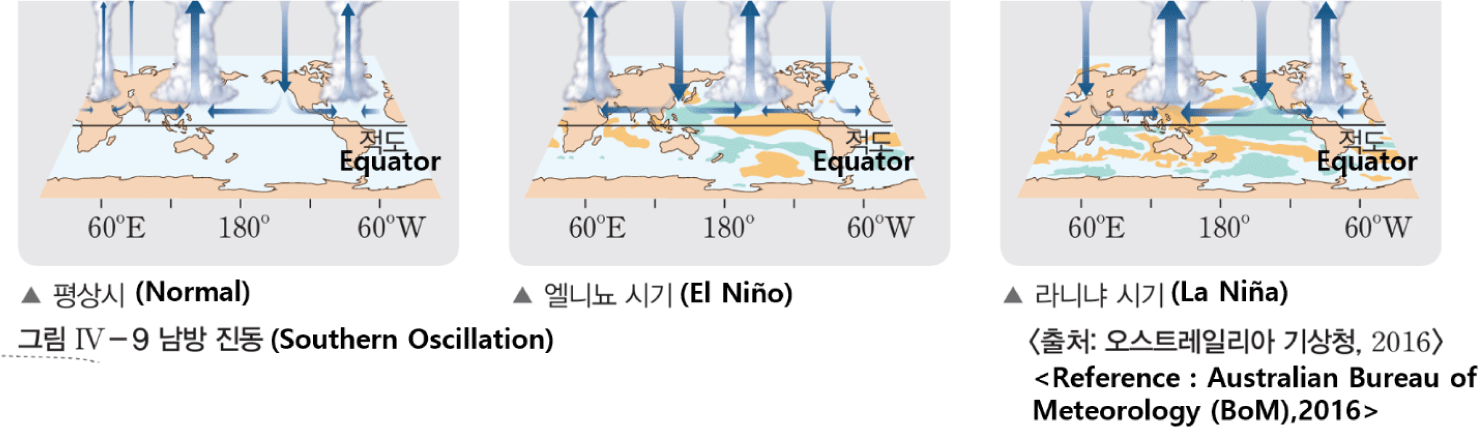
The El Niño–Southern Oscillation (ENSO) is closely linked not only to changes in SST but also to variations in atmospheric pressure, as represented by the Southern Oscillation. ENSO is known to trigger a wide range of meteorological hazards worldwide, including heatwaves, droughts, heavy rainfall, floods, and wildfires, often resulting in significant loss of life and socioeconomic damages. Given its close association with global disasters, ENSO is frequently addressed as a core instructional element in the Earth Science section of the Korean College Scholastic Ability Test [2]. Despite its educational significance, this study identified notable discrepancies in the presentation and content structure of ENSO-related topics across five domestic Earth Science I textbooks based on the 2015 revised national curriculum.
In the field of Earth Science, particularly in the study of the atmosphere and ocean, the spatiotemporal scale of phenomena is so extensive that visual resources such as digital data, photographs, and illustrations are essential for conveying the overall patterns of these systems [3]. These visual materials serve to facilitate students’ understanding of complex scientific concepts. However, by analyzing schematic diagrams of ENSO phenomena in five core textbooks, we found that many elements may lead to misconceptions. For instance, the selection of content elements depicted in the schematics—including wind, ocean currents, thermocline, upwelling, SST, and sea-level pressure—varied across different textbooks, and even the indicated directions of winds and currents differed. Chang et al. found that in-service Earth Science teachers developed misconceptions about ocean current directions during El Niño due to misinterpretation of the ENSO diagram in the 2015 revised Earth Science I textbook [4]. In addition, in some textbooks, the atmosphere and ocean were illustrated separately, making it difficult for learners to intuitively recognize ENSO as a coupled ocean-atmosphere phenomenon. Furthermore, the 2015 revised textbooks provided insufficient coverage of ENSO’s impacts on the Korean Peninsula, making it challenging for students to perceive ENSO as a phenomenon directly relevant to their everyday lives.
The 2015 revised national science curriculum specifies eight inquiry skills—problem identification, model development and application, inquiry design and implementation, data collection, analysis and interpretation, mathematical reasoning and computer utilization, conclusion drawing and evaluation, evidence-based discussion and argumentation, and communication—with the objective of fostering scientific inquiry competence through balanced acquisition of these skills [5]. However, in most of the 2015 revised Earth Science I textbooks, inquiry activities related to ENSO are largely limited to internet-based searches of disaster cases. Such simple information-gathering activities are insufficient for developing students’ scientific inquiry abilities and creative problem-solving skills. Moreover, the 2022 revised national science curriculum emphasizes, as part of the achievement standards for learning atmospheric and oceanic interactions, that: “Students should investigate the properties of seawater using satellite data; predict weather changes using weather maps or satellite images; and examine the impacts of the Southern Oscillation on daily life. In doing so, they are guided to understand the interconnectedness and interactions of Earth systems at the global scale by utilizing big data observation resources, while also experiencing digitalization of data and simulations to cultivate digital literacy” [6]. This reflects the goal of modern science education to equip students with scientific literacy by providing opportunities to solve real-world problems through inquiry-based learning while simultaneously developing their digital literacy. Therefore, there is a need to move beyond simple information retrieval activities and propose improved inquiry activities that foster digital literacy and creative problem-solving skills, which are increasingly emphasized in future societies.
In this study, a comparative analysis of the ENSO-related content in five Earth Science I textbooks based on the 2015 revised national curriculum was conducted to identify elements that may lead to misconceptions and to develop an improved ENSO schematic diagram. Although the textbook based on the 2015 revised curriculum will soon be replaced by one aligned with the 2022 revision, its analysis remains meaningful. Identifying misconceptions in this edition helps improve future textbooks and supports the correction of misunderstandings among teachers and students—an essential step for advancing science education.
Methods
This study analyzed five Earth Science I textbooks published in accordance with the 2015 revised national science curriculum for high schools in Republic of Korea. The analysis focused on the ENSO sections within the “Atmosphere-Ocean Interactions” unit, comparing the narrative approaches and identifying elements that may potentially lead to misconceptions. For this purpose, the five most widely used textbooks in current high school classrooms were selected: Visang Education (Vs), MiraeN (Mn), Chunjae Education (Cj), Kumsung (Ks), and Kyohaksa (Kh). The textbooks were analyzed based on the following four criteria:
-
Is the description of the El Niño–La Niña development process appropriate for under-standing the phenomenon as an atmosphere-ocean interactive system?
-
Are there elements in the ENSO schematics that may lead to misconceptions?
-
Do the textbooks include content on the impacts of ENSO both on the Korean Peninsula and globally?
-
Are the inquiry activities related to ENSO appropriate for fostering students’ scientific inquiry skills and digital literacy?
Results
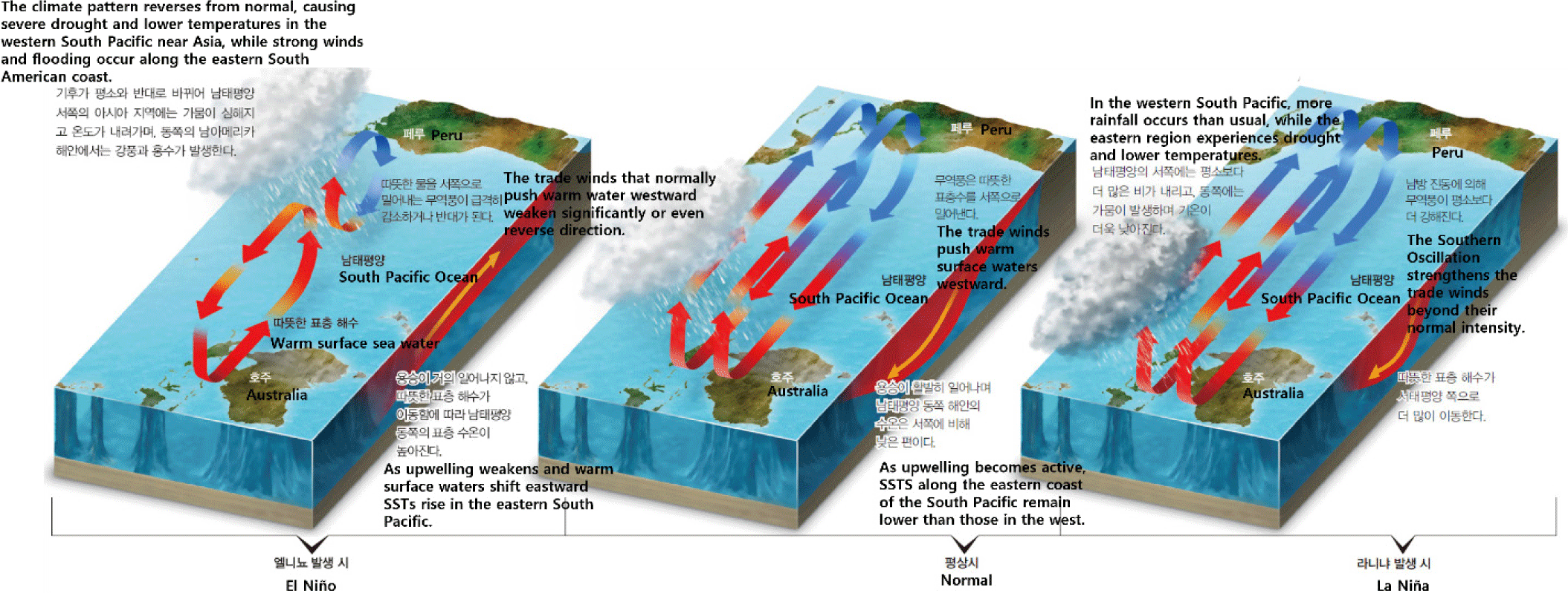
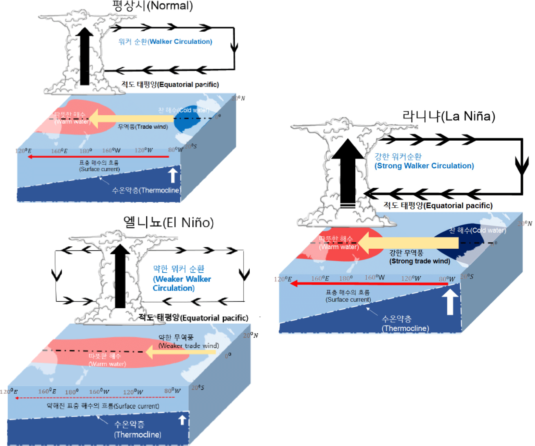
The Vs textbook explains that, under normal conditions, the trade winds cause a deepening of the warm water layer in the western equatorial Pacific while upwelling occurs in the eastern Pacific (EP), resulting in a longitudinal gradient in SST. It further describes how this temperature gradient drives the large-scale atmospheric circulation known as the Walker Circulation. The textbook introduces the concept of the Southern Oscillation by explaining that, on an irregular cycle ranging from 3 to 7 years, high pressure that typically dominates the EP weakens and low pressure develops, while high pressure forms over the western Pacific, altering the pressure distribution. El Niño and La Niña phenomena are then explained based on variations in SST and their duration. Finally, the textbook emphasizes the close relationship between changes in SST and atmospheric pressure during El Niño and La Niña events, thereby introducing the concept of ENSO. The Vs textbook presents the terminology in the following sequence: Walker Circulation → Southern Oscillation → El Niño–La Niña → ENSO.
The Vs textbook presents schematic diagrams that illustrate atmospheric and oceanic changes in the equatorial Pacific region during normal conditions, El Niño, and La Niña periods (Fig. 1). The schematics explicitly mark the locations of Australia and South America, emphasizing that ENSO phenomena occur within the equatorial Pacific region between these two continents. In the schematic for normal conditions, the textbook depicts low pressure, ascending air currents, and precipitation over the western Pacific, while high pressure, descending air currents, clear skies, and oceanic upwelling are shown over the EP, alongside the representation of the Walker Circulation. For El Niño and La Niña periods, variations in wind strength, surface ocean currents, and thermocline depth are visually compared with normal conditions by adjusting the thickness, direction, color intensity, and direction/length of the arrows.
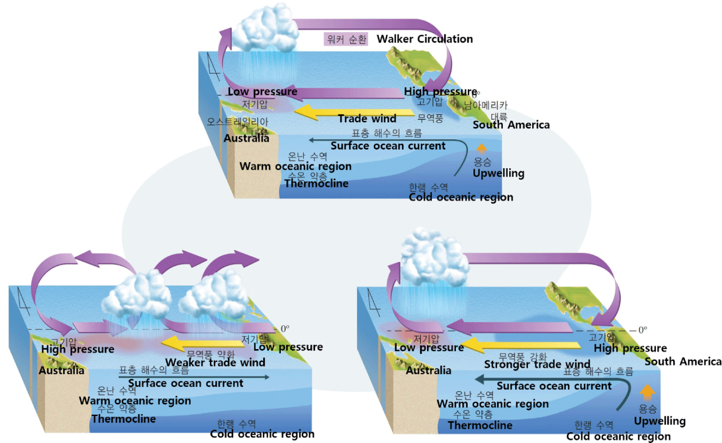
During El Niño, the schematic illustrates the eastward shift of precipitation zones from the western to the EP due to changes in pressure distribution. The reversal of surface current flow from westward (normal) to eastward (El Niño) is depicted using arrows. The weakening of trade winds is represented by shortening the length of the arrows while maintaining their direction, indicating a reduction in wind strength rather than a complete reversal. Upwelling arrows are removed for the El Niño phase, and the warm water area, which is normally concentrated in the western Pacific, is shown expanding toward the EP. Additionally, the thermocline slope is shown to flatten compared to normal conditions, with little change in the western Pacific but a deepening of the thermocline in the EP (Fig. 1). During La Niña, the schematic indicates increased precipitation, higher SST, and strengthened trade winds in the western Pacific. The enhanced surface ocean currents and upwelling are expressed through larger arrows and darker color intensity. In the EP, stronger upwelling is depicted, resulting in an expansion of the cold-water region into the CP. While the darker shading in the western Pacific suggests elevated SST compared to normal conditions, the EP is represented by an expanded area without any change in color intensity. This may lead to the misconception that SST in the EP during La Niña remain similar to those under normal conditions.
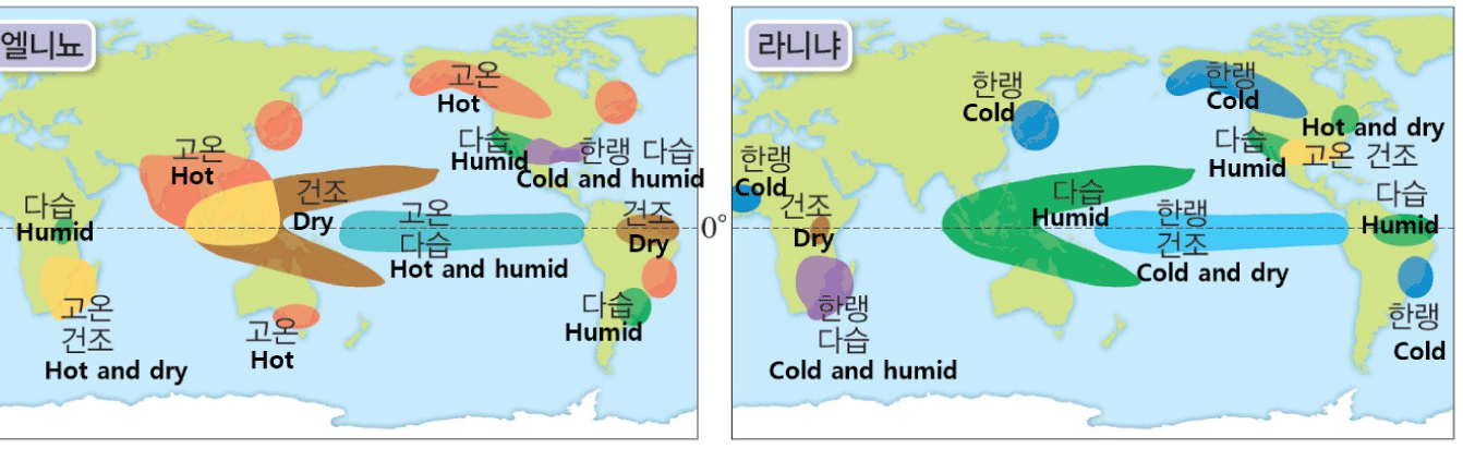
The Vs textbook describes the ENSO impacts of El Niño and La Niña, including the spread of diseases and changes in agricultural production. Using Fig. 2, it further explains the worldwide effects of ENSO. While the figure allows students to infer that El Niño tends to bring abnormally high winter temperatures to the Korean Peninsula and La Niña leads to abnormally low winter temperatures, the textbook lacks a direct explanation of ENSO’s specific impacts on the Korean Peninsula.
The Vs textbook includes a total of two inquiry activities, both primarily focused on data interpretation and information gathering. The first activity involves analyzing SST anomaly data during El Niño and La Niña periods to explain the pressure distribution over the western and EP. The second activity, titled “Investigating Cases of Global Environmental Changes Caused by El Niño and La Niña and Their Impacts on Our Lives,” requires students to form groups, investigate cases of global weather anomalies and oceanic environmental changes, engage in discussions, and present their findings. Both inquiry activities in the Vs textbook mainly emphasize the skill of data collection, analysis, and interpretation—one of the eight inquiry skills outlined in the 2015 revised national science curriculum. However, they fall short in fostering students’ broader scientific inquiry competencies and digital literacy.
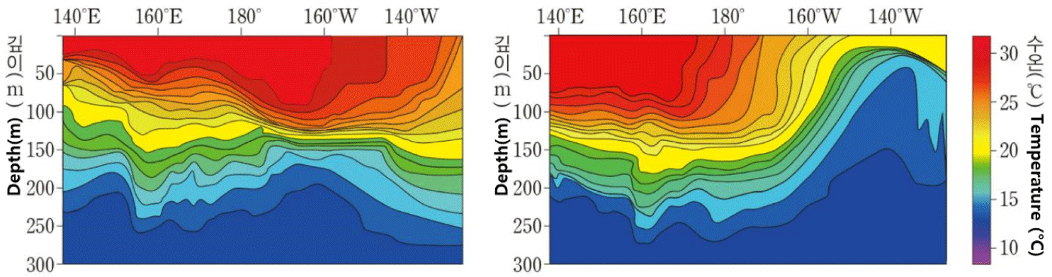
The Mn textbook explains that, under normal conditions, active upwelling occurs along the Peruvian coast of South America, as evidenced by the distribution of marine plankton. From late December to March of the following year, the weakening of the trade winds reduces upwelling, leading to an increase in SST along the Peruvian coast, which negatively affects local fisheries. The textbook introduces the historical background of the El Niño phenomenon by noting that, beginning in the 1980s, sustained increases in SST lasting more than a year and recurring every 3 to 7 years were observed off the Peruvian coast. This marked the point at which the phenomenoncame to be established as a scientific term, formally recognized as El Niño. Subsequently, El Niño and La Niña is defined based on SST anomalies and the duration of its anomaly. Using a vertical cross-sectional diagram of Pacific Ocean temperatures (Fig. 3), it explains variations in the thermocline slope and SST during El Niño and La Niña events.
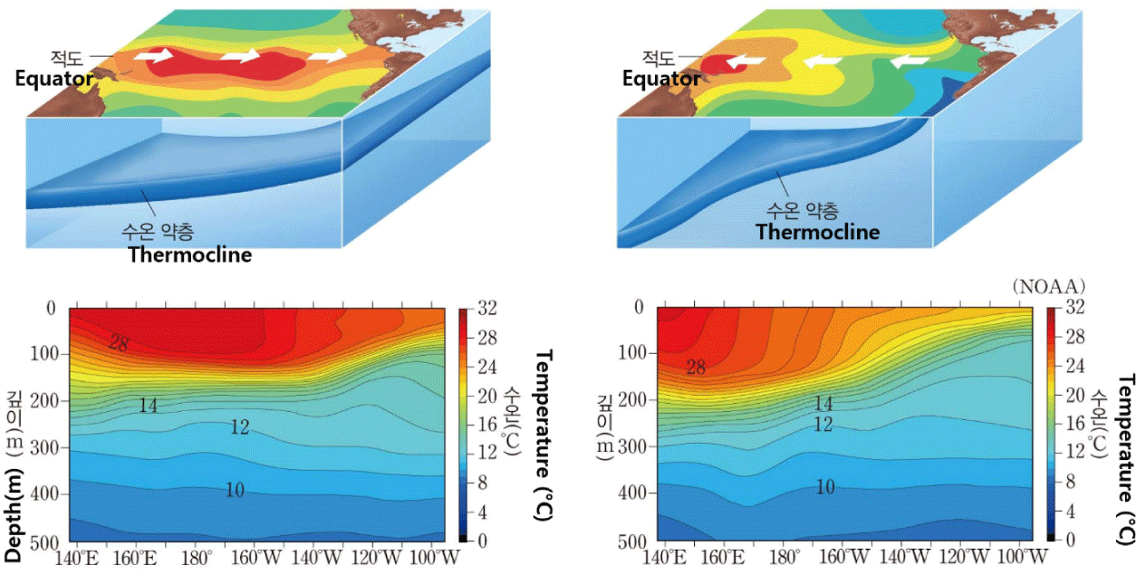
Under normal conditions, the Mn textbook explains that, due to the influence of the trade winds, the equatorial currents in the tropical Pacific flow from east to west, transporting more heat and moisture to the relatively warmer atmosphere over the western Pacific (Fig. 3). It then introduces the concept of the Walker Circulation, describing how low pressure develops over the western Pacific surface while the converging air over the EP descends, forming high pressure at the surface. Using Fig. 4, the textbook illustrates how the Walker Circulation changes during El Niño and La Niña events, and explains the resulting weather impacts in terms of hurricanes, typhoons, floods, and droughts. Subsequently, it introduces the concept of the Southern Oscillation and explains that ENSO arises from the coupled interactions between the atmosphere and ocean. The Mn textbook presents the mechanism in the following order: El Niño–La Niña → Walker Circulation → Southern Oscillation → ENSO.
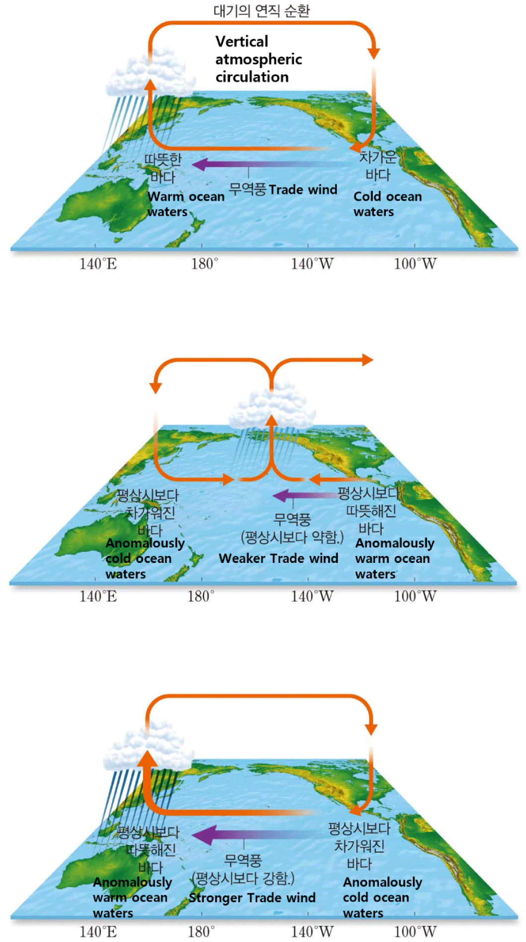
The Mn textbook presents both horizontal and vertical sea temperature distributions in the equatorial Pacific during El Niño and La Niña periods (Fig. 3). Using white arrows indicating the inferred movement of warm water and isothermal contour diagrams that depict thermocline slope and temperature variations, the textbook provides a three-dimensional representation of temperature changes at both surface and subsurface levels. In Fig. 4, three-dimensional schematics of the Walker Circulation are presented for normal, El Niño, and La Niña conditions. These diagrams include representations of continents to indicate the equatorial Pacific region, as well as information on longitude, precipitation zones, variations in trade wind strength, and SST changes.
Unlike the other four textbooks, the Mn textbook does not provide a schematic diagram of normal conditions in its illustrations of the vertical ocean temperature distribution. By omitting a comparison with normal conditions, the textbook overlooks an important element necessary for systematically understanding El Niño and La Niña phenomena. In addition, as in Figs. 3 and 4, oceanic and atmospheric processes are presented in separate diagrams, making it difficult to explicitly convey ENSO as a coupled ocean-atmosphere interaction system. In Fig. 3, the white arrows appear to indicate the movement of warm water, but students may mistakenly interpret them as representing the direction of the trade winds, potentially leading to misconceptions. Furthermore, the schematics do not include elements such as the intensity of upwelling or atmospheric pressure, resulting in a general lack of comprehensive information about the mechanisms involved.
The textbook explains that when El Niño or La Niña occurs, the interactions between the atmosphere and ocean deviate from normal conditions, resulting in abnormal climate patterns across various regions of the world. However, no explanation is provided regarding the impacts of these phenomena on the climate of the Korean Peninsula.
The Mn textbook presents two inquiry activities. The first activity, titled “What climate changes occur due to El Niño, La Niña, and the Southern Oscillation (ENSO)?” introduces extreme weather events (hurricanes, floods, droughts) observed in the EP, Indonesia, and North America. Students are asked to determine during which phase—El Niño or La Niña—these events are likely to occur. This is followed by a concept confirmation and data interpretation task in which students explain the causes of these extreme weather events based on changes in SST and atmospheric pressure distribution. The second activity, titled “How do El Niño and La Niña affect climate variations and our lives” provides SST and its anomaly data for the tropical Pacific from 1986 to 2016. Students identify the periods during which El Niño and La Niña events occurred and investigate climate variation cases that took place during those periods.
Both activities primarily emphasize the skill of data collection, analysis, and interpretation—one of the eight inquiry skills specified in the 2015 revised national science curriculum—thus providing limited opportunities for students to develop broader scientific inquiry competence and digital literacy. However, the Mn textbook distinguishes itself from other textbooks by offering students the opportunity to predict climate changes based on rising SST in the tropical Pacific and explore the relationship between global warming and El Niño, thereby enabling them to acquire diverse information related to climate change.
The Cj textbook describes El Niño as a sequence of trade wind weakening, reduced upwelling, and increased SST in the EP, while defining La Niña as the opposite phase. Using Fig. 5, the textbook explains changes in thermocline depth during El Niño and La Niña events, and introduces the concept of the Southern Oscillation as an east-west pressure variation with Fig. 6. It further explains how variations in SST in the tropical Pacific alter pressure distributions and atmospheric circulation, detailing the pressure changes over the eastern and western Pacific during normal, El Niño, and La Niña conditions. Finally, the concept of ENSO is introduced, emphasizing the close relationship among ENSO. The Cj textbook presents the terminology in the following sequence: El Niño–La Niña → Southern Oscillation → ENSO. Notably, the textbook distinguishes itself from others by introducing scientists Walker and Bjerknes, thereby providing historical context for the development of the ENSO concept.
In Fig. 7, the left panel depicts atmospheric circulation and sea surface height anomalies during normal, El Niño, and La Niña periods, while the right panel illustrates SST and their anomalies. In the schematics, specific terms such as “upwelling” and “thermocline” are not explicitly labeled. Additionally, no explanation is provided for the white arrows in Fig. 7 (left), leaving room for students to misinterpret them as trade winds. In reality, during El Niño events, the trade winds do not reverse direction from west to east, but rather weaken in strength; failure to clarify this distinction may lead to misconceptions about wind behavior associated with El Niño.
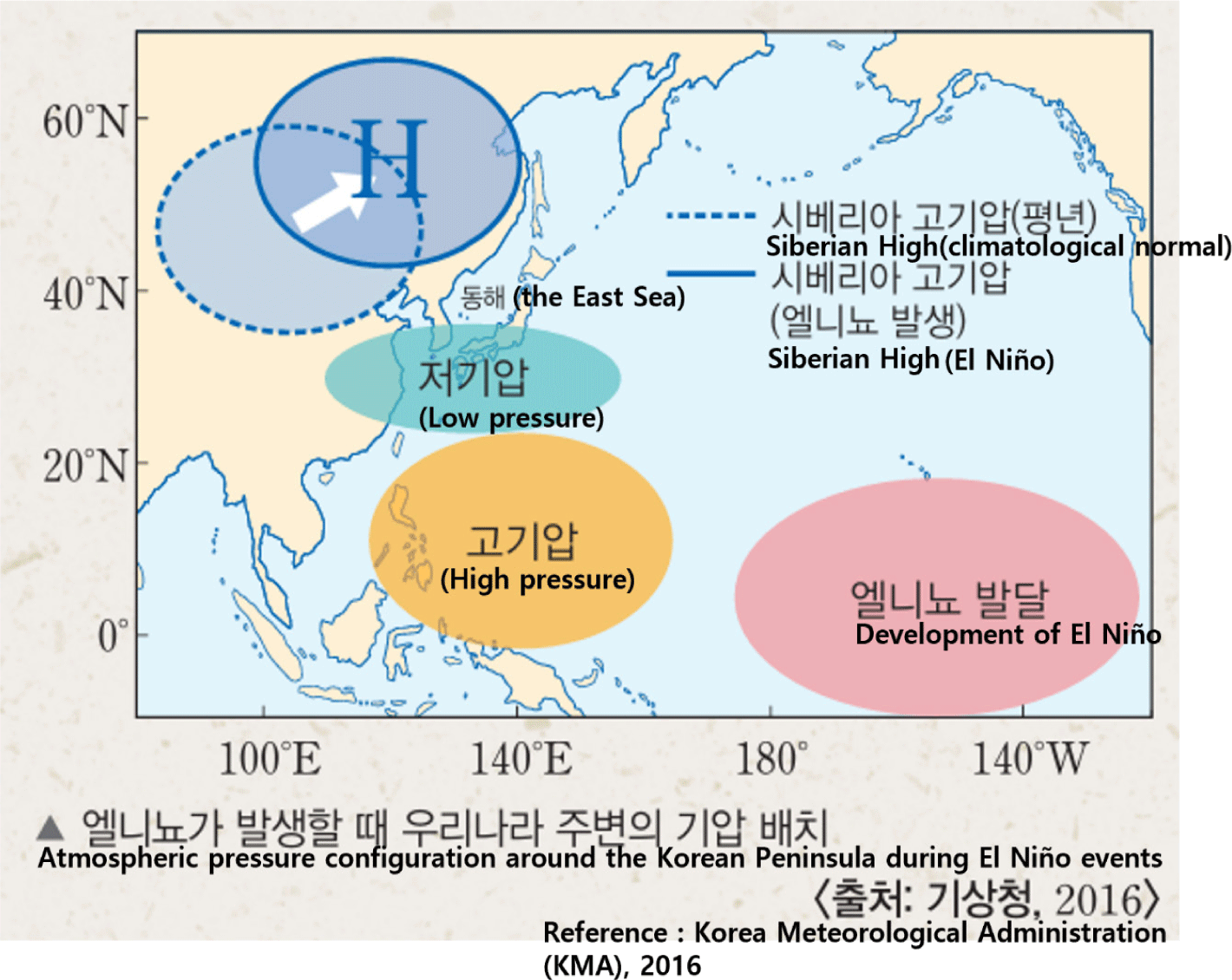
Among the five textbooks analyzed, the Cj textbook is the only one that explains the weather pattern changes and underlying mechanisms affecting East Asia, including the Korean Peninsula, during El Niño and La Niña periods. In the “Strengthening Core Competencies” section, Fig. 8 illustrates that during El Niño winters, the Siberian High shifts northward, resulting in heavier snowfall and warmer-than-average temperatures on the Korean Peninsula, whereas colder winters occur during La Niña events. Through these supplementary reading materials, the textbook provides an explanation of how El Niño and La Niña influence the weather in Korea and globally via specific atmospheric mechanisms.
The Cj textbook includes an inquiry activity titled “Investigating the Impacts of Phenomena Such as El Niño and La Niña on Our Lives,” which involves data interpretation and group discussions. In this activity, students are instructed to identify the years in which El Niño and La Niña events occurred after 2000, and to investigate examples of climate variations and their impacts corresponding to those years. This activity primarily requires students to collect information on climate variation cases via the Internet, which aligns with the data collection skill—one of the eight inquiry skills specified in the 2015 revised national science curriculum. However, this relatively simple information-gathering approach may offer limited opportunities to foster students’ digital literacy and scientific inquiry competence.
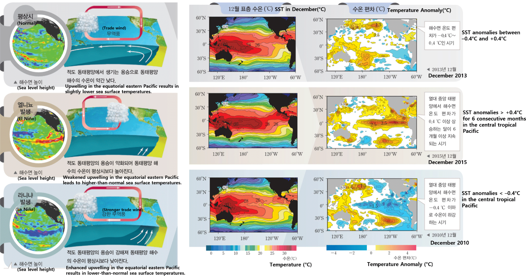
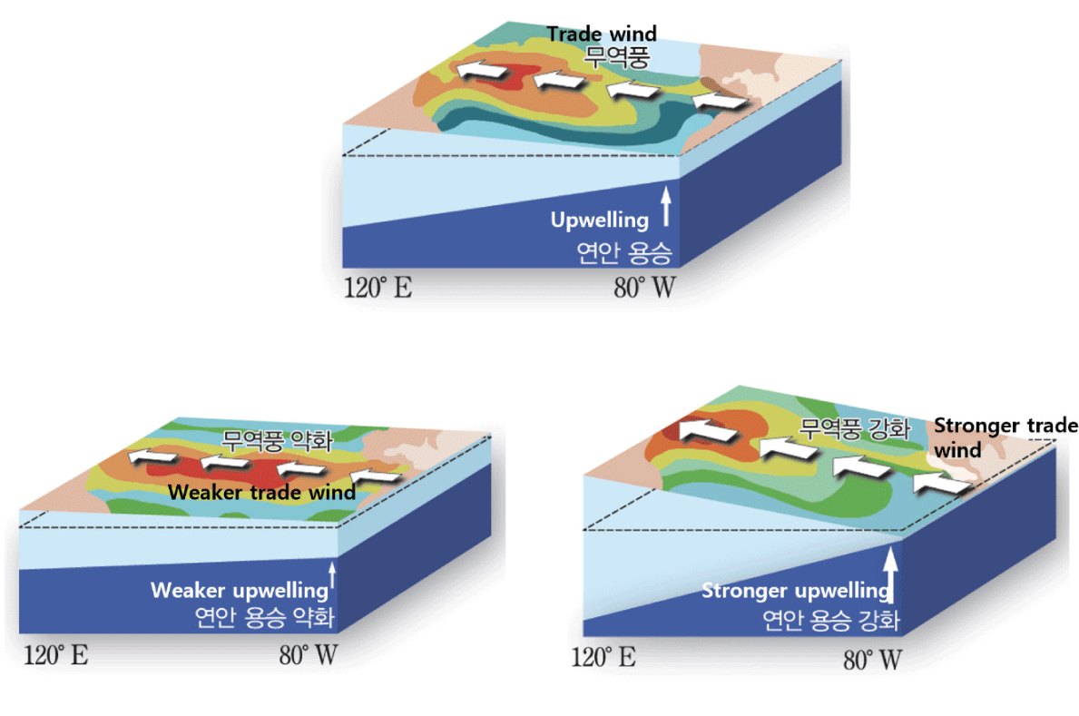
The Ks textbook explains that, under normal conditions, upwelling occurs along the coasts of Peru and Ecuador as surface water displaced by the trade winds is replaced by cooler subsurface water, while warm surface water accumulates along the Australian coast, leading to subsidence. When the trade winds weaken, upwelling off the coast of Peru is suppressed, causing SST in that region to rise—a phenomenon defined as El Niño. Conversely, when SST decrease below normal levels, the condition is defined as La Niña. The textbook then introduces the concept of the Southern Oscillation by explaining that changes in SST during El Niño events alter the atmospheric pressure distribution compared to normal conditions. It explains that the Southern Oscillation Index (SOI) is generally positive under normal conditions but turns negative during El Niño events, thus linking the atmospheric phenomenon of the Southern Oscillation with the oceanic phenomenon of El Niño.
Compared to the other textbooks, the Ks textbook provides a more detailed explanation of the Southern Oscillation, uniquely describing it as the difference in monthly mean sea-level pressure between Tahiti and Darwin. However, under normal conditions, the SOI generally fluctuates near zero, with deviations below –1 and above +1 indicating El Niño and La Niña events, respectively. Therefore, the description about SOI index is incorrect for normal years. Furthermore, unlike the other four textbooks, the Ks textbook does not introduce the concept of ENSO, nor does it provide explanations of the Walker Circulation or the thermocline, which limits its comprehensiveness in addressing the full atmosphere-ocean coupling involved.
The Ks textbook presents schematic diagrams that simultaneously depict both atmospheric and oceanic changes during normal, El Niño, and La Niña conditions (Fig. 9). To help indicate the approximate locations where ENSO phenomena occur, the names of relevant countries are also included. In Fig. 9, atmospheric circulation is represented using arrows with two distinct colors (red for the western Pacific and blue for the EP); however, no explanation is provided regarding the meaning of these colors. Additionally, the flow of surface ocean currents is illustrated in a way that may suggest the movement of warm water from deeper layers, potentially leading to misconceptions about the vertical structure of oceanic processes.
In the inquiry activity of the Ks textbook, students are presented with data on average temperature, minimum temperature, and number of precipitation days in Korea during El Niño periods and are asked to analyze the characteristics of the Korean climate variations during El Niño events. However, the activity is limited to simple identification of increases or decreases in temperature and precipitation frequency, without providing opportunities for deeper analysis of the underlying mechanisms or broader climatic impacts. In particular, the global impacts of El Niño are not directly addressed in the main text but are instead covered indirectly through the inquiry activity.
The Ks textbook includes an inquiry activity titled “Investigating the Impacts of El Niño and La Niña on daily life,” in which students analyze the multifaceted impacts of El Niño—including climatic, ecological, and socioeconomic effects—using real-world news articles. The activity presents cases such as drought damages in Thailand and the cancellation of Korea’s smelt fishing festival due to abnormally warm temperatures during the 2015 El Niño event. Notably, the Ks textbook differentiates itself from the other textbooks by specifically including tasks that require students to investigate the climatic characteristics of Korea during El Niño and La Niña periods. However, the activity primarily involves simple data interpretation based on tables showing increases in temperature and precipitation, thus focusing solely on the data interpretation skill—one of the eight inquiry skills emphasized in the 2015 revised national science curriculum.
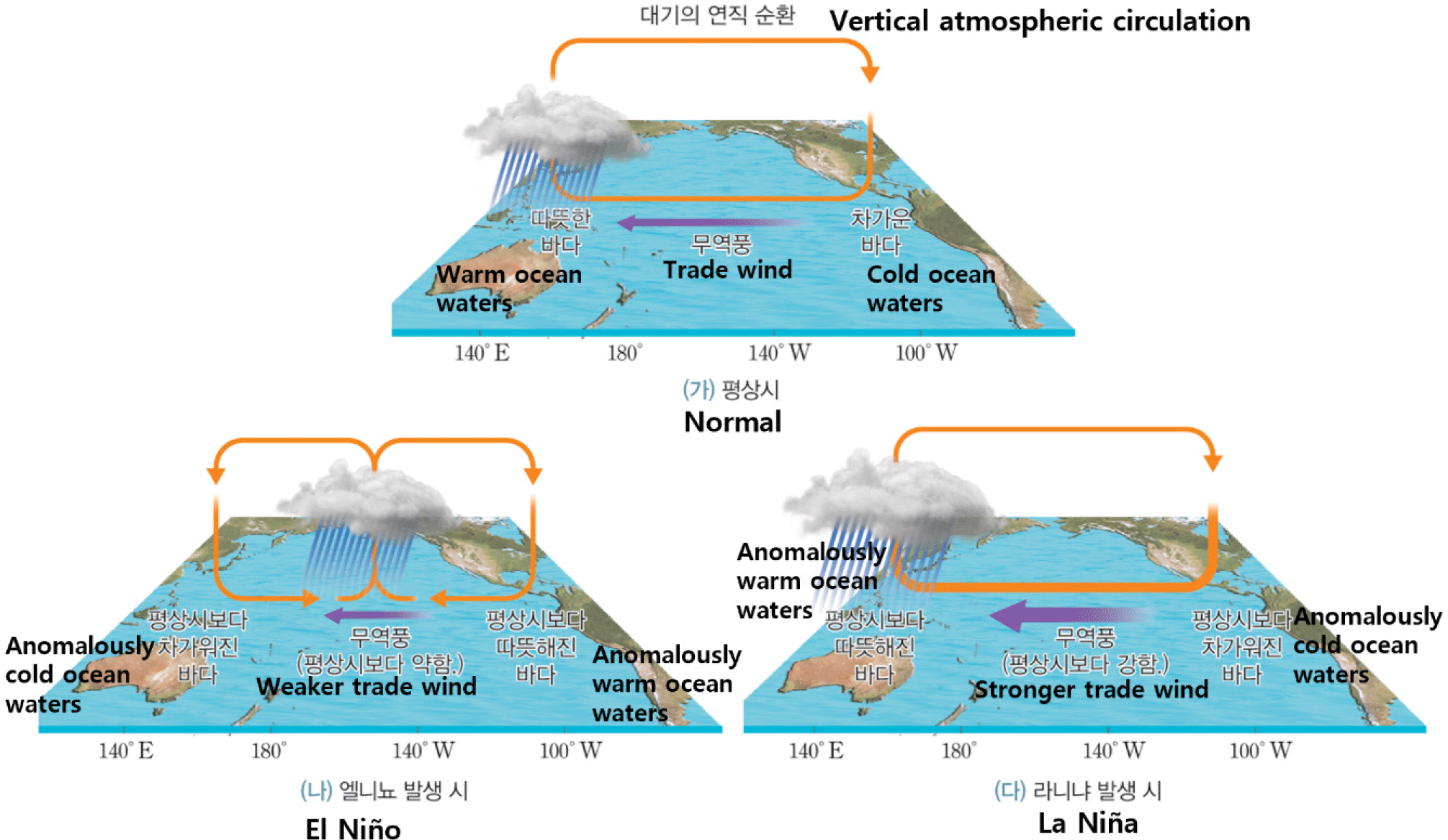
The Kh textbook explains that, under normal conditions, the western Pacific exhibits higher SST, sea level heights, and a thicker mixed layer with a deeper thermocline compared to the EP. Under normal conditions, upwelling off the coast of Peru sustains rich fisheries. Around Christmas, weakened trade winds suppress upwelling and raise SSTs—a phenomenon known as El Niño, meaning “the Christ Child.” The textbook then explains the changes occurring during El Niño and La Niña events using Fig. 10, which illustrates variations in upwelling, trade wind strength, sea level height, SST, and the thickness of the warm water layer. Additionally, the textbook uniquely notes that during winter, the southward shift of the Intertropical Convergence Zone (ITCZ) contributes to the weakening of the trade winds.
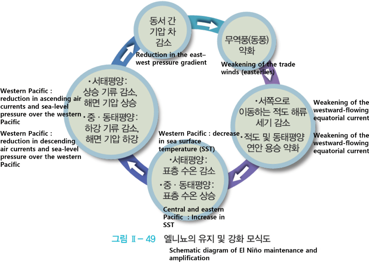
Unlike the other textbooks, the Kh textbook introduces the ENSO feedback mechanism using a schematic diagram (Fig. 11). It also adds that while this schematic effectively accounts for the intensification and maintenance of El Niño, it cannot fully explain the termination of El Niño or the transition to La Niña. The Kh textbook organizes its content in the sequence of El Niño–La Niña → Southern Oscillation → Walker Circulation → ENSO, and provides a historical background on the origin of the terms El Niño and La Niña. Furthermore, by introducing the ITCZ concept and presenting the ENSO feedback process, it offers students a deeper understanding of El Niño dynamics and an opportunity to develop scientific reasoning skills.
Similar to the Mn textbook, the Kh textbook presents separate schematic diagrams for oceanic temperature structure and atmospheric circulation under normal, El Niño, and La Niña conditions. In Fig. 10, which illustrates the oceanic temperature structure, the textbook depicts variations in trade wind strength, upwelling intensity, thermocline slope, and SST to represent changes in oceanic conditions. It also indicates longitudinal positions corresponding to the western and EP. It also shows the eastward expansion of the warm pool during El Niño events. Fig. 12, which resembles Fig. 4 from the Mn textbook, presents a three-dimensional representation of atmospheric circulation. However, by presenting the oceanic and atmospheric processes in separate diagrams, the Kh textbook makes it more difficult for students to intuitively grasp ENSO as a coupled ocean-atmosphere interaction system.
The Kh textbook notes that prices of agricultural imports in Korea exhibit pronounced volatility during El Niño–La Niña. However, it does not provide an accompanying explanation of climate variations in Korea. Notably, Kh textbook is the only one of the five textbooks to introduce the term “teleconnection”, explaining that anomalies in the tropical Pacific can influence distant regions via the propagation of atmospheric waves. It also indicates a close linkage between global warming and changes in the intensity of El Niño, which distinguishes Kh from the other textbooks.
The Kh textbook includes a single inquiry activity titled “Investigating the Impacts of El Niño and La Niña.” In this activity, students are provided with a graph of the SOI calculated from 1950 to 2016 and are tasked with identifying the periods during which El Niño and La Niña events occurred. Subsequently, they are asked to infer the relationship between these periods and fluctuations in coffee prices. Following this, students investigate various types of El Niño-related damages worldwide and create a corresponding damage distribution map. Unlike the inquiry activities in the other four textbooks, which primarily focus on collecting case studies of disaster impacts, the Kh textbook uniquely incorporates an exploration of economic changes resulting from El Niño and La Niña. Nevertheless, since the activity is still centered on simple data collection, analysis, and interpretation, it provides limited opportunities to foster students’ scientific inquiry competence and digital literacy.
The results of the analysis of the five textbooks are summarized in Tables 1 and 2. While variations exist among the textbooks, most present the content in chronological order according to the historical introduction of scientific terms such as El Niño–La Niña, Walker Circulation, Southern Oscillation, and ENSO (Table 1). Structuring the content based on the historical development of scientific concepts allows students to recognize the nature of science, understanding that scientific knowledge is not fixed but is continually refined through scientific advancements.
| Standard\Tb | Vs | Mn | Cj | Ks | Kh |
|---|---|---|---|---|---|
| Descriptive mechanism sequences | Walker circulation→ Southern Oscillation→ El Niño–La Niña → ENSO |
El Niño–La Niña→ Walker circulation→ Southern Oscillation→ ENSO |
El Niño–La Niña→ Southern Oscillation→ ENSO |
El Niño–La Niña→ Southern Oscillation |
El Niño–La Niña→ Southern Oscillation→ Walker Circulation→ ENSO |
| ENSO impacts | Indirectly presented through Fig. 2 | Not presented | Presented through Fig. 8 | Partly presented through inquiry activity | Partly presented through the concept of “teleconnection” |
| Inquiry activities | Surface-level inquiry and minimal digital engagement through data collection and interpretation. | Partial extension of inquiry through prediction and reasoning with limited digital integration. | Basic information gathering with restricted inquiry development and digital literacy. | Applied inquiry through real- world cases with limited descriptive digital analysis. | Multidimensional inquiry linking science and economics with basic digital practices. |
| Textbook | Misconception components |
|---|---|
| Vs | - (Fig. 1) Lack of color intensity differentiation for the eastern Pacific region during La Niña, potentially causing misconceptions about SST conditions. |
| Mn | - (Fig. 3) No explanation provided for the white arrows, which may be misinterpreted as trade wind directions. - Atmospheric and oceanic processes presented in separate schematics, making the coupled interaction of ENSO less intuitive. |
| Cj | - (Fig. 7) No explanation provided for the white arrows, creating potential for misinterpretation. |
| Ks | - (Fig. 9) No explanation provided for the meaning of the colors used to represent atmospheric circulation. - Arrows depicting surface warm water movement may misleadingly suggest vertical movement from deeper ocean layers, leading to possible misconceptions. |
| Kh | - Atmospheric and oceanic processes presented in separate schematics, limiting intuitive understanding of ENSO as an atmosphere-ocean coupled system. |
In terms of presenting the global and regional impacts of ENSO, most textbooks primarily focus on the climate variations in the equatorial Pacific region. Among the five textbooks, only the Cj textbook incorporates a detailed explanation of ENSO’s effects on the Korean Peninsula. The remaining four textbooks only provide fragmented information on the impacts of ENSO on the Korean Peninsula.
Although all five textbooks include inquiry activities related to ENSO, notable differences exist in their approaches. In the Vs and Cj textbooks, the inquiry activities primarily involve simple data collection tasks. The Mn textbook includes a question that prompts students to explore the effects of ENSO from a climate change perspective, by estimating climate variations associated with rising tropical Pacific SST due to global warming. The Ks and Kh textbooks present inquiry activities focused on investigating the socioeconomic impacts of ENSO. Overall, most of the inquiry activities in the current Earth Science I textbooks are limited to simple fact-finding tasks and fragmented analysis and interpretation based on textbook-provided content. Meanwhile, the explanations provided in the current 2015 revised textbooks primarily focus on the EP El Niño mechanism and corresponding schematic representations. However, given that CP El Niño events have become more frequent than EP El Niño events in recent years, it would be desirable for textbooks to incorporate these developments and address the diversity of El Niño types [7].
Table 2 summarizes the misconception-inducing elements identified in the five textbooks. In the Vs textbook, Fig. 1 does not indicate color intensity for the EP region during La Niña, potentially leading students to overlook changes in SST anomalies during La Niña events. In the Mn textbook, no explanation is provided for the white arrows above the sea surface in Fig. 3, which may cause students to mistakenly interpret them as indicating the direction of the trade winds. In the Cj textbook, the absence of an explanation for the white arrows in Fig. 7 may create confusion in interpreting the schematic. In the Ks textbook, the absence of clarification for the color coding representing atmospheric circulation in Fig. 9 may contribute to misconceptions. Furthermore, in Fig. 9, the flow of warm surface water is illustrated in a manner that may give the false impression that warm water is moving from the deep ocean, potentially leading to additional misconceptions.
Although ENSO is fundamentally a phenomenon that arises from ocean-atmosphere interactions, two of the textbooks (Mn and Kh) present separate schematics for the oceanic and atmospheric systems. Moreover, none of the textbooks provide a comprehensive schematic that simultaneously incorporates all essential elements required to fully understand El Niño and La Niña phenomena, such as upwelling, thermocline depth variation, surface ocean current flow, SST changes, geographical indicators (continents or latitude-longitude coordinates) identifying the location of El Niño and La Niña events, and sea-level pressure distribution.
In this study, an improved ENSO schematic diagram (Fig. 13) was developed to address the shortcomings identified in the existing textbooks. Specifically, the following elements have been comprehensively incorporated:
(1) The changes in the direction and strength of trade winds and ocean currents are clearly depicted. Previous research on misconceptions has identified that in-service Earth Science teachers often hold the misconception that surface ocean currents reverse direction during El Niño events [4]. Since this misunderstanding can lead to further conceptual errors, the schematic presents the movement of warm surface water based on its actual flow direction under natural conditions, rather than illustrating anomalies. This approach aims to facilitate an accurate understanding of the movement of warm surface water in the equatorial region during El Niño and reduce potential confusion.
(2) Appropriate schematic representations were utilized within the diagram to depict ENSO-related concepts, and each visual element was explicitly labeled to clarify the corresponding conceptual components. The depths of the thermocline, SST, and the spatial extents of warm and cold water regions were presented separately for normal, El Niño, and La Niña conditions. To clearly illustrate the distinct characteristics of each phase, the diagram incorporates appropriate graphic elements such as variations in arrow size, thickness, and shading intensity, along with clearly defined labels embedded within the schematic.
(3) The schematic clearly indicates the geographical locations where El Niño phenomena occur by including the Australian continents to represent the western equatorial Pacific, and the South American continent to represent the EP. In addition, latitude and longitude coordinates are explicitly marked to further enhance spatial accuracy and geographic context.
(4) To intuitively convey that El Niño and La Niña are phenomena resulting from ocean-atmosphere interactions, the schematic integrates both oceanic and atmospheric system variations within a single comprehensive diagram.
However, it should be noted that Fig. 13 is designed to most effectively illustrate the general mechanisms of El Niño and La Niña, and caution must be exercised to avoid overgeneralizing these phenomena. In reality, El Niño and La Niña exhibit considerable variability, appearing in forms such as CP El Niño and EP El Niño. The schematic presented primarily reflects the typical characteristics of an EP El Niño, which generally occurs when trade winds weaken [1].
Conclusion and Recommendations
In this study, the ENSO sections of five domestic Earth Science I textbooks, developed under the 2015 revised curriculum, were analyzed to identify potential misconception-inducing elements and to propose an improved schematic diagram that addresses the limitations found in existing ENSO representations. The analysis revealed that the conceptual components included in ENSO schematics varied across textbooks, and many contained elements that could lead to misconceptions. Only one of the five textbooks provided a detailed explanation of ENSO’s impact on the Korean Peninsula while most inquiry activities focused primarily on investigating case studies of ENSO-induced disasters worldwide.
Based on this in-depth textbook analysis, an improved ENSO schematic was developed to minimize possible misconceptions during ENSO instruction. Additionally, inquiry activities aligned with the achievement standards and considerations of the 2022 revised science curriculum were proposed to help students develop scientific inquiry competencies and digital literacy.
In school settings, textbooks serve as essential guidelines and instructional resources for teaching and learning. Therefore, the development of textbooks must be grounded in thorough content research to ensure scientific accuracy, while carefully structuring content to foster students’ competency development. Prior to the creation of Earth Science textbooks aligned with the revised curriculum, it is crucial to review and analyze the ENSO-related content presented in existing Earth Science textbooks. Furthermore, digital literacy, which is emphasized in the 2022 revised curriculum, represents a core competency in 21st-century scientific research. To enhance students’ scientific inquiry abilities and interest in science, inquiry activities should prioritize solving real-life problems and incorporate advanced activities that reflect current scientific research trends, rather than relying on simple, memorization-based tasks.
This analysis of the 2015 textbook provides a critical foundation for evaluating and improving the upcoming revised textbook based on the 2022 curriculum. Future research will build on these findings to assess how effectively the new textbook addresses previously identified misconceptions and enhances conceptual understanding in Earth Science classrooms.