
Introduction
Hurricanes and typhoons are among the most devastating natural hazards, affecting millions of lives annually across coastal regions worldwide. These powerful storms are fueled by warm ocean waters and produce high winds, heavy rainfall, and storm surges that can cause catastrophic damage. As the intensity and frequency of tropical storms increase due to a warming climate [1], it has become increasingly critical to help future generations understand the science behind these storms and make informed decisions in the face of their potential impacts [2].
Hazard literacy should be viewed as part of the broader concept of scientific literacy, which refers to the knowledge and understanding of scientific concepts and processes necessary for personal decision-making, participating in civic and sociocultural discourse, and engaging in economic productivity [3]. Hazard literacy for hurricanes thus involves knowledge and understanding of hurricane-related science concepts, the methods used to investigate and forecast them, and the socioeconomic impacts they may cause. Hurricane hazard-literate individuals and communities are expected to make productive decisions while anticipating and mitigating potential impacts and increasing preparedness for protection.
However, teaching about hurricanes is challenging because they are large, dynamic, and complex systems. First, investigating complex systems-including those that produce hurricanes-is impossible in science labs since they cannot be generated or manipulated as they occur in nature [4]. Second, forecasting their position and intensity depends on sophisticated models that simulate atmospheric and oceanic interactions, but these models are designed for scientists, not students [5]. Third, for those without personal knowledge or direct experience with natural hazards, envisioning impacts and identifying effective mitigation strategies can be difficult [6].
Computer simulations are well suited to address these difficulties [7]. By engaging secondary students in interactive simulations that mimic simplified aspects of storm modeling, they can explore the dynamic factors influencing hurricane behavior, make forecasts about where hurricanes might move, and assess impact regions and severity. Through these activities, students can also reflect on the uncertainties inherent in forecasting and social implications. In this paper, we first delineate hazard-related terms and define hurricane hazard literacy. We then characterize simulations as computational models and introduce the Hurricane Explorer as a simulation tool for secondary school students to investigate various hurricane scenarios. We describe the Hurricane Module, an online curriculum module that strategically employed the Hurricane Explorer to engage students in experimentation and modeling to develop hurricane hazard literacy. Using pre- and posttest results, we assess student hazard literacy understanding cross student demographic groups and whether students’ engagement with simulations in the Hurricane Module significantly predicted students’ hazard literacy outcomes while controlling for student demographic variables, prior hurricane literacy knowledge, and module completion. We then discuss the implications of these findings.
Hurricane Hazard Literacy
Hazards are events or conditions that pose a threat to the well-being of individuals and communities by causing loss or damage to life, property, and the environment [8]. Hazards can result from human activities, such as nuclear wastes and chemical spills. They can also arise from natural processes such as earthquakes, volcanic eruptions, hurricanes, floods, and wildfires. Not all naturally occurring phenomena become hazards unless they approach areas where people live or where critical resources are located. This is why, for the Gulf and East Coasts of the USA, despite the occurrence of 20 or more tropical storms annually over the North Atlantic Ocean, only a few—typically two or three—impact coastal communities and are reported in the news. Therefore, we define natural hazards as natural phenomena that pose a risk of loss or damage due to their proximity to individuals and communities or resources they value [9]. Hazards originate from these natural or human-driven events, while the losses and damages represent the consequences from their interaction with people and the environment. The concept of risk is commonly used by scientists and the media for hazard communication.
Risk focuses on what might happen in the future due to hazards, rather than what has already occurred [10]. When scientists assess risk, they use forecasts rather than predictions. Forecasting emphasizes a probabilistic consideration of future conditions, acknowledging uncertainty and reflecting a range of possible outcomes needed for informed decision-making. In contrast, predictions imply more definitive statements about the future, often based on prior knowledge, established processes, or well-defined theories. Risk, therefore, is used to estimate the potential impact on tangible resources—such as financial losses in dollars or the number of affected individuals—based on the likelihood of the event [8]. This concept of risk is what students are likely to encounter in everyday life and also most critical for hazard literacy [11]. To understand risk, students must first grasp several key aspects of natural hazards: (1) what causes a natural phenomenon to form and progress (factors), (2) how a hazardous event can be forecasted (likelihood), (3) what consequences and damages could be caused by the hazard (impacts), and (4) how damages and losses can be reduced (mitigation strategies) [12].
Moreover, the communication of risk associated with hurricane hazard forecasts has shifted from definitive, clear-cut messaging to approaches that incorporate probabilistic information, leading to more complex decision-making processes. This evolution affects both local authorities who must determine which areas should be evacuated and when to issue evacuation orders and residents in potentially affected areas who must decide whether to evacuate and how to protect their properties. Scientific uncertainty inherent in forecasting storm progression and potential impacts has become a standard practice for hurricane hazard communication. For example, the National Hurricane Center has been releasing cone of uncertainty graphics to the public since 2002, which were quickly adopted by weather forecasters nationwide [13]. More recently, spaghetti plots—which depict multiple storm paths generated by different computational models—have gained prominence and are widely circulated through social media platforms, becoming a key tool for communicating hurricane forecast uncertainty to the public [14]. These probabilistic storm path visualizations convey where a hurricane might be headed, when it might arrive, and its potential impacts—all while representing the uncertainties involved in these forecasts.
Based on the risk-related concepts outlined above, we developed eight statements addressing hurricane literacy, as shown in Table 1. These statements represent key domain-specific content necessary for students to develop a scientific understanding of natural hazards and risks. The learning goals of the Hurricane Module, as shown in the second column of the table, bridge between content-based literacy statements and activities in the module. For example, H1 states that “hurricanes are natural phenomena that form over tropical oceans.” To support students in recognizing this, the beginning of the first activity in the module has students identify hurricanes in satellite images by observing visual features such as the eye, eyewall, and swirling cloud bands near the center of a storm. An assessment item in the hurricane literacy test shows a satellite photo of a hurricane in which students identify where the strongest winds can be found. This alignment shows how the student activities address hurricane literacy statements that are targeted by the assessment.
To support assessment alignment with the hurricane literacy statements, we collected and evaluated relevant items from a range of released standardized tests and various state assessments that addressed hurricane-related science content and impacts. In addition, we designed original assessment items. All assessment items were reviewed by a panel of hurricane scientists, teachers, educational researchers, and assessment specialists to ensure they were clear, age-appropriate, and readable for secondary school students.
Computer Simulations to Engage Students in Scientific Processes
While hurricane literacy statements describe what knowledge or understanding students need, we argue that students also need to know the scientific process that generates the knowledge. Traditionally, hurricane communication has been disseminated through media outlets, as well as by government agencies, professional organizations, and community groups. In recent years, however, this landscape has shifted dramatically. Members of the public increasingly access and share forecasting information through the Internet and social media, which exposes them to potential misinformation, misunderstanding, and misinterpretation. To navigate this complex information ecosystem, students must be able not only to interpret forecasting information but also to distinguish credible information from misinformation [15]. Achieving this requires an understanding of epistemics—the processes by which forecasting information is generated [3]. Such epistemic understanding equips students to be critical consumers of forecasting information, including cone of uncertainty maps and hurricane advisories, enabling them to make informed decisions amidst an overwhelming volume of information with varying levels of scientific credibility [15].
In investigating natural phenomena such as hurricanes, scientists create models that capture essential aspects of a system and manipulate these representations to observe and build explanations [16]. These models can take different forms, including physical models constructed with materials and instruments; mathematical models expressed through symbols, equations, and operators; and computational simulations built with parameter sets, algorithms, and input-output interfaces [17]. Because these models are designed for experimentation, scientists can isolate variables, modify specific components of the system, and test hypothetical relationships. This process enables them to observe outcomes, refine their understanding, strengthen theoretical frameworks, and make predictions. Although these models represent real-world phenomena, they operate within the constraints of their conceptual, material, mathematical, or computational contexts. While individual features of a model may align with those of the real-world system, the interactions between these features often do not directly correspond. For example, the interaction between winds generated by a pressure system and those from a tropical storm center is a physical process in the real world. However, in a computer simulation, this interaction is represented mathematically and algorithmically, occurring within a computational space rather than through actual physical forces. This creates both affordances and limitations that must be considered when relating the model back to the real-world phenomenon it is intended to represent. It is not just the model itself that requires careful scrutiny—anything scientists discover or conclude through modeling should also be critically examined and evaluated in relation to the real-world context [18].
Simulations are computational models built on mathematical constructs and operations that allow initial parameters to be changed [19]. They illustrate theories by representing relationships between system variables and external factors surrounding the system and are particularly useful when manual calculations are impractical due to complexity or time constraints [20]. Simulations rely on computational algorithms to perform stepwise calculations, iteratively refining parameter estimates to extend a system’s state beyond its initial conditions [21]. For example, hurricane simulations attempt to represent real-world hurricanes by modeling atmospheric and oceanic interactions, such as wind patterns, sea surface temperatures, and pressure systems. These simulations rely on algorithms and mathematical relationships to simulate a storm’s track and intensity. However, because simulations operate within computational frameworks, they cannot fully replicate the complexity of real-world dynamic conditions. This gap introduces uncertainty when translating findings from the simulated context to real-world hurricane forecasting.
Weather forecasting involves using computational models and conducting numerical analyses to simulate the evolution of the atmosphere and its interactions with other components of the Earth system. These models rely on equations describing atmospheric flow and are highly sensitive to the initial conditions provided. This sensitivity leads to the growth of forecast errors over time, ultimately limiting long-term forecasting. Two primary sources of uncertainty in weather forecasting come from the simulation process and the simulation outcome. In the simulation process, (1) italicize uncertainty occurs due to difficulties in capturing all the factors involved in the state of the Earth system at the start of the simulation, and (2) italicize occurs due to the approximations, assumptions, and algorithmic limitations of capturing complex physical processes. As a result of these uncertainties, simulation outcomes also contain uncertainty defined as ensemble uncertainty, reflecting variability across multiple models or model runs at a given time, as well as temporal uncertainty, reflecting the run-to-run variability within a single model as weather data are updated with new observations.
Despite the inherent uncertainty in hurricane forecasting, paying attention to forecasts is critical for preparedness, risk assessment, and decision-making. Even though exact storm tracks and intensities cannot be determined with complete certainty, forecasts provide early warnings that help individuals and communities prepare, secure property, and evacuate if necessary. Forecasts also guide emergency response efforts, allowing authorities to issue evacuation orders, deploy resources, and coordinate disaster responses based on projected risks. While uncertainty exists, hurricane forecasting has become increasingly accurate over time, with probabilistic models offering a range of possible scenarios rather than absolute predictions. Ignoring forecasts can have severe consequences, as seen in past hurricanes where underestimating risks led to loss of life, extensive damage, and overwhelmed emergency response systems. Moreover, uncertainty should not be taken as unpredictability; rather, it highlights the complex nature of atmospheric systems and the need for continuous monitoring.
While scientists use simulations to advance their theoretical understanding of natural phenomena through computational modeling, simulations are also widely employed for educational purposes. In these contexts, interactive visualization interfaces are essential for allowing students to explore phenomena that are otherwise impossible to investigate, easily set initial conditions, change variables, generate phenomena, observe how they unfold, and interpret results in an engaging and user-friendly environment. Simulations are commonly used in science classrooms to teach scientific concepts, processes, and the nature of science effectively to learners across all educational levels, from elementary school to university [22]. Furthermore, simulations provide opportunities for students to reflect on the epistemological limitations in extending simulation-based evidence to real-world phenomena.
Designing Simulation-Based Investigations
We consider simulations as a form of inscription, described as a range of “symbolic tools that can be used for representing aspects of the world that are theoretically important” [23] (p. 168). Inscriptions are designed to retain their form and function so that their meaning can remain stable as they move beyond their original context for broader communication [24]. However, this stability does not guarantee that new users will interpret inscriptions in the same way as their creators. While the Hurricane Explorer, described below, is designed to illustrate how environmental factors influence storm tracks, students’ engagement with the simulation is uniquely shaped by their social contexts, conceptual understanding, and epistemological perspectives. As a result, students’ interactions with the simulation may diverge from the original intent, leading to diverse and sometimes unexpected learning outcomes. Therefore, we carefully designed both the Hurricane Explorer and the accompanying student investigations in the Hurricane Module to ensure that their designs are coordinated and mutually reinforcing, creating a synergistic learning experience that effectively supports the development of hurricane literacy.
The Hurricane Explorer (See Fig. 1) is an interactive scientific visualization tool that simulates the progression of a North Atlantic tropical storm originating off the coast of Africa under various initial conditions set by students, including average sea surface temperature and the locations and sizes of atmospheric high- and low-pressure systems. By adjusting these variables, students can observe how the storm’s track and intensity evolve over time. The simulation also illustrates precipitation levels and how wind direction and speed interact with the storm’s movement, contributing to storm surge.
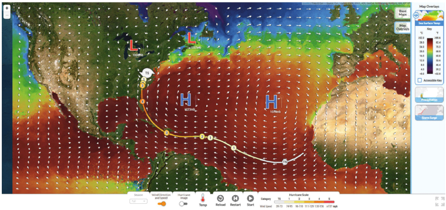
The Hurricane Explorer offers customizable base maps. The satellite map provides a satellite view of Earth’s surface, enabling students to identify geographic features and land-water boundaries. The relief map or terrain map represents the topography of an area, which is useful for exploring how features such as low-lying coastal plains are inundated by storm surges and flooding. The street map shows human infrastructure, important for investigating the potential impacts of storms on populated areas and the infrastructure. By toggling between these maps, students can analyze how geographic, topographic, and social factors may interact with storm dynamics.
The Hurricane Explorer also includes several data overlays. The sea surface temperature overlay uses a gradient of colors to illustrate the variation of ocean temperature. The precipitation overlay shows rainfall amounts along a storm track. The storm surge overlay provides a visual representation of water levels in coastal areas. In addition, the Hurricane Explorer allows students to adjust the position and strength of high- and low-pressure systems over the Atlantic Ocean and observe how these atmospheric pressure systems influence storm tracks and intensity. Seasonal settings enable students to explore how tropical storms vary across different times of the year. Visual labels for tropical storm development stages provide a guide to storm intensity categories. Arrows, which change length and direction as a storm moves, provide a visual indication of wind speed and direction over the Atlantic Ocean. The Hurricane Explorer features controls to reload, restart, and run scenarios, enabling students to examine storm development within a single trial and to conduct multiple experimental trials to generate different scenarios.
Through interactions with the Hurricane Explorer, students can isolate and investigate the impact of individual environmental factors on hurricane development and progression, including changes in storm severity, tracks, and impact areas. By adjusting multiple variables, students can also explore how complex interactions shape real-world storm behavior. The Hurricane Explorer is designed not only to visualize hurricane phenomena but also to help students transfer their understanding from simulation-based investigations to real-world hurricanes and interpret professional hurricane forecasts produced by scientists during storm events.
The Hurricane Explorer is used within the Hurricane Module to support students’ investigations into the factors influencing how a tropical storm evolves into a hurricane and eventually dissipates. While a simulation is a powerful tool, it does not address all aspects of hurricane literacy outlined in Table 1. Therefore, the simulation is strategically integrated into activities where it is most instructionally valuable. To comprehensively address the learning goals, a range of instructional resources, including hurricane impact photos, official advisories, historical hurricane track maps, satellite imagery and videos, and educational content developed by trusted weather authorities such as the National Oceanic and Atmospheric Administration (NOAA) are woven into the activity as well. Finally, case studies of real hurricane events are used to engage students with authentic real-world hazards and impacts experienced by actual communities.
The guiding question for the online Hurricane Module is: “How will hurricane risks and impacts change over the next 100 years?” This question encourages students to consider how the intensity and frequency of hurricanes may shift in response to changing environmental conditions. The Hurricane Module consists of five activities, each designed to last approximately 45 minutes. Table 2 presents the sequence of these five activities, with each activity comprising five to seven web pages. The table also highlights the resources used to support students’ engagement and how each activity aligns with hurricane literacy statements H1 through H8 in Table 1. Students interact with various elements on each web page—such as simulations, videos, graphs, and question response fields—and these interactions are automatically logged. Each web page builds on the previous one, and each activity builds on prior learning, creating a coherent progression that supports the development of hurricane hazard literacy. Across the activities, there are a total of 136 locations in which students interact with a simulation and respond to multiple-choice, open-ended, or snapshot prompts. The Hurricane Explorer is used on eight web pages.
With the Hurricane Explorer, students can learn about the causal factors influencing hurricane intensity and track changes. To investigate how pressure system locations affect storm movement in Activity 2, students can place two high- and two low-pressure systems anywhere in the simulation and observe how air flows around these systems. Around high-pressure systems, students can observe that winds blow clockwise from the center. They can adjust the high-pressure system’s strength from 1,015 mb to 1,028 mb, with stronger systems showing larger arrows compared to weaker ones. Similarly, students can examine wind patterns around low-pressure systems, which can be set from 997 mb to 1,010 mb, noticing that winds blow counterclockwise around the center of these systems.
By manipulating the locations and strengths of pressure centers, students can create different distributions of high- and low-pressure systems. Fig. 2 illustrates three arrangements: (1) both high-pressure centers set at 1,028 mb, (2) a high-pressure center at 1,028 mb on the right and another high-pressure center at 1,015 mb on the left, and (3) a high-pressure center at 1,028 mb with a low-pressure center at 997 mb. Although all tropical storms begin at the same location in these scenarios, Fig. 2 shows that their progressions vary significantly while other factors, such as sea surface temperature distributions, remain identical. This variation occurs because a tropical storm, which is a low-pressure system with its own rotational winds, evolves dynamically as the combined influence of surrounding wind patterns follows the vector sums of all winds generated by these pressure systems. By analyzing multiple scenarios, students are expected to learn that as a hurricane moves, winds from a high-pressure system steer the storm away from the center of the system. In contrast, when a hurricane approaches a low-pressure system, it is drawn toward the system.
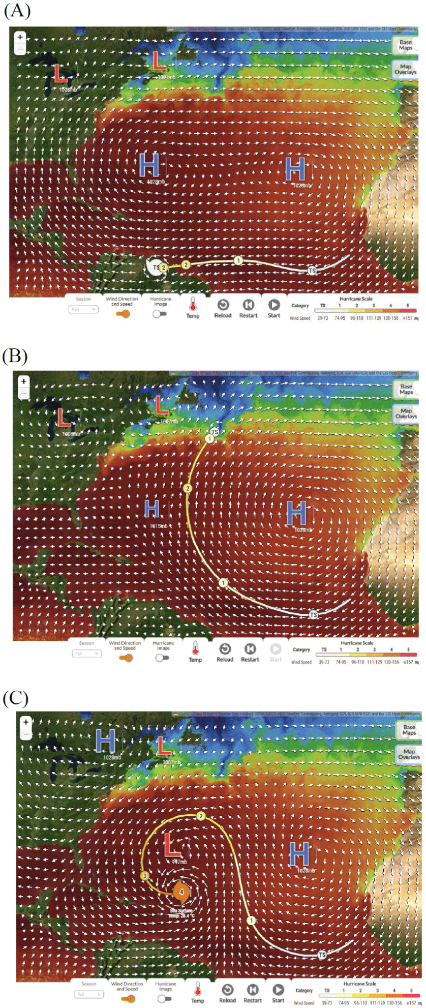
Once students develop an understanding of the relationship between pressure systems and storm paths, they apply this knowledge to two real-world situations using the Hurricane Explorer. In the first application, students explore the Bermuda High, a semi-permanent high-pressure system over the Atlantic Ocean whose strength and location varies depending on the season. The simulation begins with a high-pressure system at the location where the Bermuda High is typically located. Students adjust these pressure systems in order to investigate how its position influences storm trajectories as they cross the Atlantic. In the second application, students change the locations and strengths of several pressure systems to try to recreate the path of Hurricane Florence, a Category 4 hurricane that struck the Carolinas in September 2018.
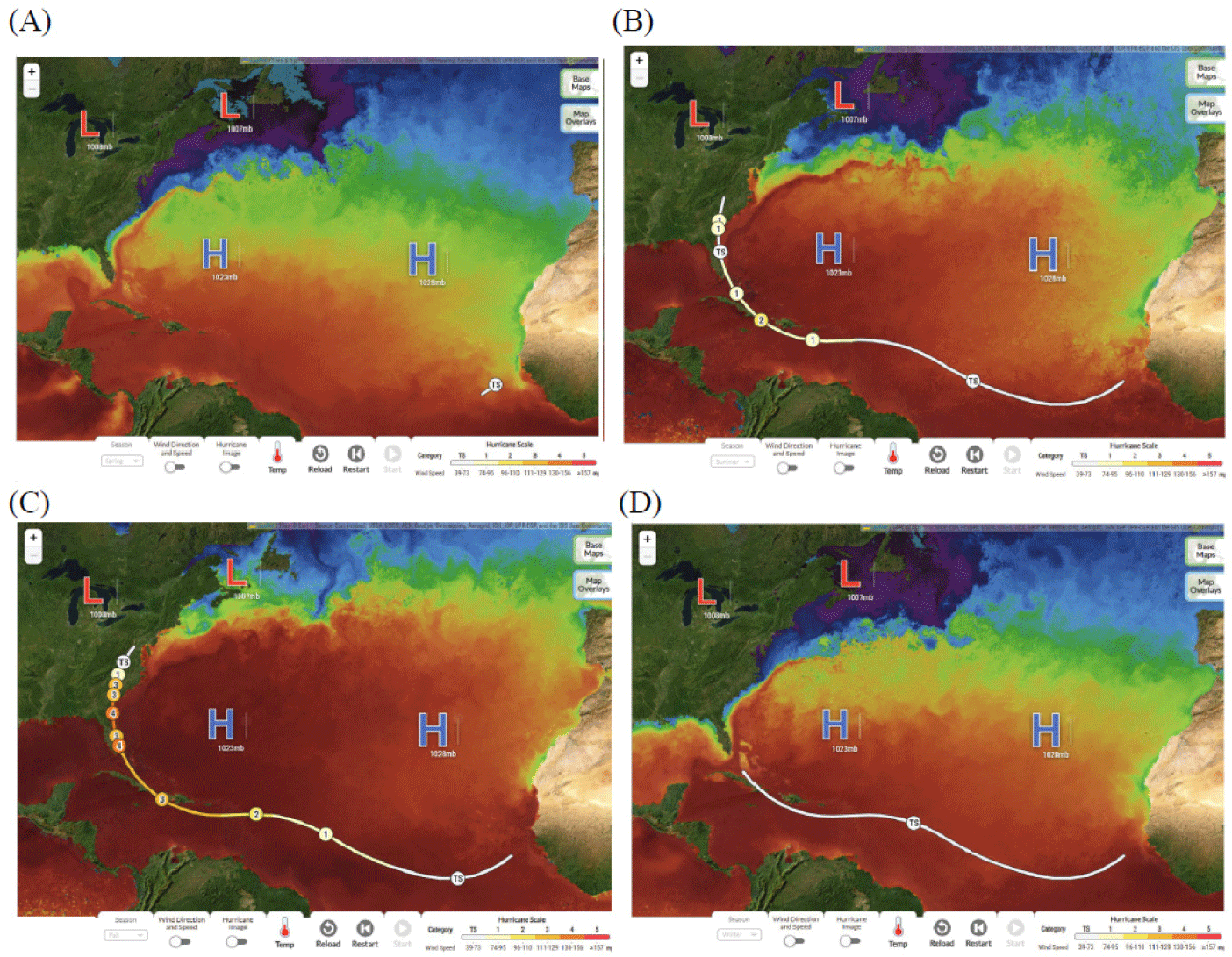
In Activity 3 students explore how sea surface temperature affects hurricane formation and progression. Temperature is a key factor since hurricanes develop over warm ocean waters with temperatures of at least 27°C. The Hurricane Explorer provides four sea surface temperature maps, allowing students to observe how sea surface temperature distributions vary by season and location. They can note that ocean temperatures are highest in the fall near the East Coast and coolest in the spring. Fig. 3 illustrates how the same arrangement of high-pressure systems leads to different tropical storm developments across four seasonal scenarios. In the fall, when the sea surface temperatures are the warmest, the tropical storm in the simulation develops into a Category 3 hurricane and impacts more communities along the East Coast of the USA. For the other three seasons, while the storm paths begin the same due to the wind conditions set by the same pressure systems, the storms in the winter and spring do not even reach the continent; the storm intensity differs across all three scenarios. Through these experiences, students are expected to learn that (1) hurricanes intensify when they move over warm waters, (2) the most intense hurricanes typically occur in the fall when ocean temperatures are at their highest, and (3) the Atlantic hurricane season extends from June 1 to November 30 as a result of these seasonal temperature patterns.
In Activity 4, students learn about three primary hurricane hazards: strong winds, heavy precipitation, and storm surge through photos of hurricane damage such as fallen trees, damaged roofs and houses, and flooded streets. These visuals help students connect hazard types and duration to the real-world impacts. Using the Hurricane Explorer, students create a simulated hurricane path whose track reaches the USA and analyze their simulated hurricane in terms of the category of the storm correlated to estimate potential wind damage. For example, a Category 2 hurricane has wind speeds between 154 and 177 km/h. Students then use the map overlays feature to identify affected areas based on precipitation and storm surge levels.
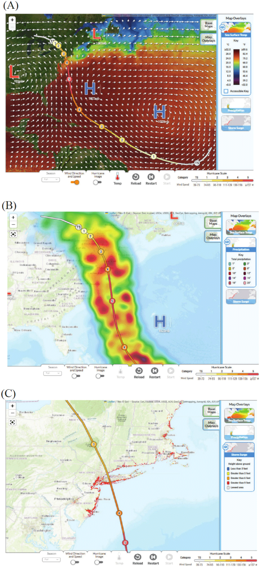
Fig. 4 presents three snapshots of the Hurricane Explorer that illustrate different aspects of hurricane forecasting based on simulated hurricane tracks. In Fig. 4(a), the hurricane path is displayed with wind vectors over a satellite image, combined with the sea surface temperature overlay, allowing students to analyze how ocean temperature influences storm development. Fig. 4(b) shows the precipitation overlay on a geographic map, enabling students to compare areas of heavier rainfall with those receiving less precipitation. To enhance precision, students can zoom in and examine specific locations in greater detail. Fig. 4(c) highlights storm surge areas along the coast as well as inland riverbanks, illustrating where elevated water levels may reach when a storm surge occurs. By integrating these overlays, students analyze winds, storm surge, and heavy precipitation zones, mirroring the analysis meteorologists perform when issuing hurricane advisories. To synthesize their findings, students write a news story that communicates the hazards and impacts of a hurricane, reinforcing their ability to translate simulation results into real-world risk communication.
In Activity 5 students consider long-term hurricane forecasts by examining data showing an overall increase in sea surface temperatures and sea level rise, then making conjectures about how hurricane intensity and frequency may change over the next 100 years if the global atmospheric warming trend continues. Given that hurricane formation and intensification depend on warm ocean waters, students can infer that future hurricanes are likely to become more frequent and intense. Students use the Hurricane Explorer to generate a storm track and reason about how hurricanes in the same location might behave under future climate conditions. By engaging in both short-term and long-term forecasting, students develop a deeper understanding of the complexities and uncertainties involved in forecasting hurricane paths and impacts. This process helps bridge the gap between simulation-based modeling and real-world hazard communication, reinforcing the challenges scientists face in forecasting and preparing for extreme weather events.
Following simulation explorations students reflect on sources of uncertainty. While the Hurricane Explorer simulation allows students to change sea surface temperature and atmospheric pressure systems, it does not account for all variables that influence hurricane behavior. Student reflections can focus on how wind and pressure systems are simplified in the simulation or how real-world ocean temperatures vary over time. Students might also consider other atmospheric conditions that are not represented in the Hurricane Explorer such as humidity, upper-level winds, and interactions between multiple weather systems that evolve constantly. By considering the limitations of the underlying computational model, students reflect on the ways in which models simplify nature’s complexities to make understanding the phenomena easier and make forecasts feasible. This awareness helps students develop a more nuanced perspective on the challenges of real-world hurricane forecasting and the role of uncertainty in these forecasts.
Students are also guided to use their experiences with simulation-based forecasting to interpret scientific visualizations such as cone of uncertainty maps and spaghetti plots. These activities reinforce the probabilistic nature of forecasting where even small variations in environmental conditions can lead to different storm trajectories and intensities and help students understand why real-world hurricane forecasting necessarily includes a range of possible outcomes rather than a single precise storm path. Students also learn to recognize the inherent uncertainty in hurricane forecasts and develop critical thinking skills necessary to interpret scientific forecasts and make informed decisions in uncertain situations. Because the exact landfall location and intensity of an approaching storm cannot be precisely determined too far in advance, students learn that impact areas can shift from initial forecasts and cover a wide region beyond the track itself. This highlights the importance of preparedness across a wider region, as communities beyond the forecasted path may still experience significant effects from a storm.
At the conclusion of each forecasting investigation, students have the opportunity to assess hurricane hazards and risks for communities that could be impacted based on simulation results. They can also brainstorm potential mitigation strategies within the context of different populations and evolving socioeconomic trends. Through guided exploration, students examine how risk increases due to population growth and the rising concentration of people in hazard-prone areas and consider the disproportionate impact of hurricanes on vulnerable individuals and communities, particularly those affected by poverty, age, or disability. By integrating these considerations, students develop a more comprehensive understanding of hurricane risk and recognize the importance of addressing social factors as a critical component of hurricane literacy.
To examine the extent to which secondary school students developed hurricane literacy, we conducted a one-group pretest-posttest study. We recruited four high school teachers and three middle school teachers from across the USA (AZ, KY, PA, NC, NY, IL, and FL) through social media announcements and email listservs. During recruitment, we sought a balance across several contextual factors, including school setting (urban, suburban, rural), socioeconomic status (as indicated by free lunch percentages), school level (middle vs. high school), and geographic proximity to hurricane-prone areas (see Table 3 for details.).
Teacher surveys revealed that all seven participating teachers held science teaching certifications, with individual specialties including biology, general science, Earth science, and physics and math. All but one teacher taught in public schools. Reported free lunch percentages across participating schools ranged from 18% to 90%, indicating a wide socioeconomic spectrum. Three teachers identified their school areas as prone to hurricanes. Two teachers reported teaching hurricanes for the first time. One teacher had prior experience using the Hurricane Module and also reported frequent use of simulations in science instruction. Four teachers reported using simulations sometimes, while two teachers had not used simulations in their teaching prior to this study.
As part of their participation, teachers agreed to implement the Hurricane Module using provided pedagogical resources and support materials. Specifically, they committed to reviewing the Teacher Edition of the Hurricane Module and accompanying online resources in advance, administering the hurricane literacy pretest, implementing the module, administering the hurricane literacy posttest, and taking the teacher post-implementation survey. During implementation, teachers were encouraged to track student progress and provide feedback using the online Class Dashboard accompanying the module. A stipend was provided upon fulfillment of all participation requirements by the specified deadline.
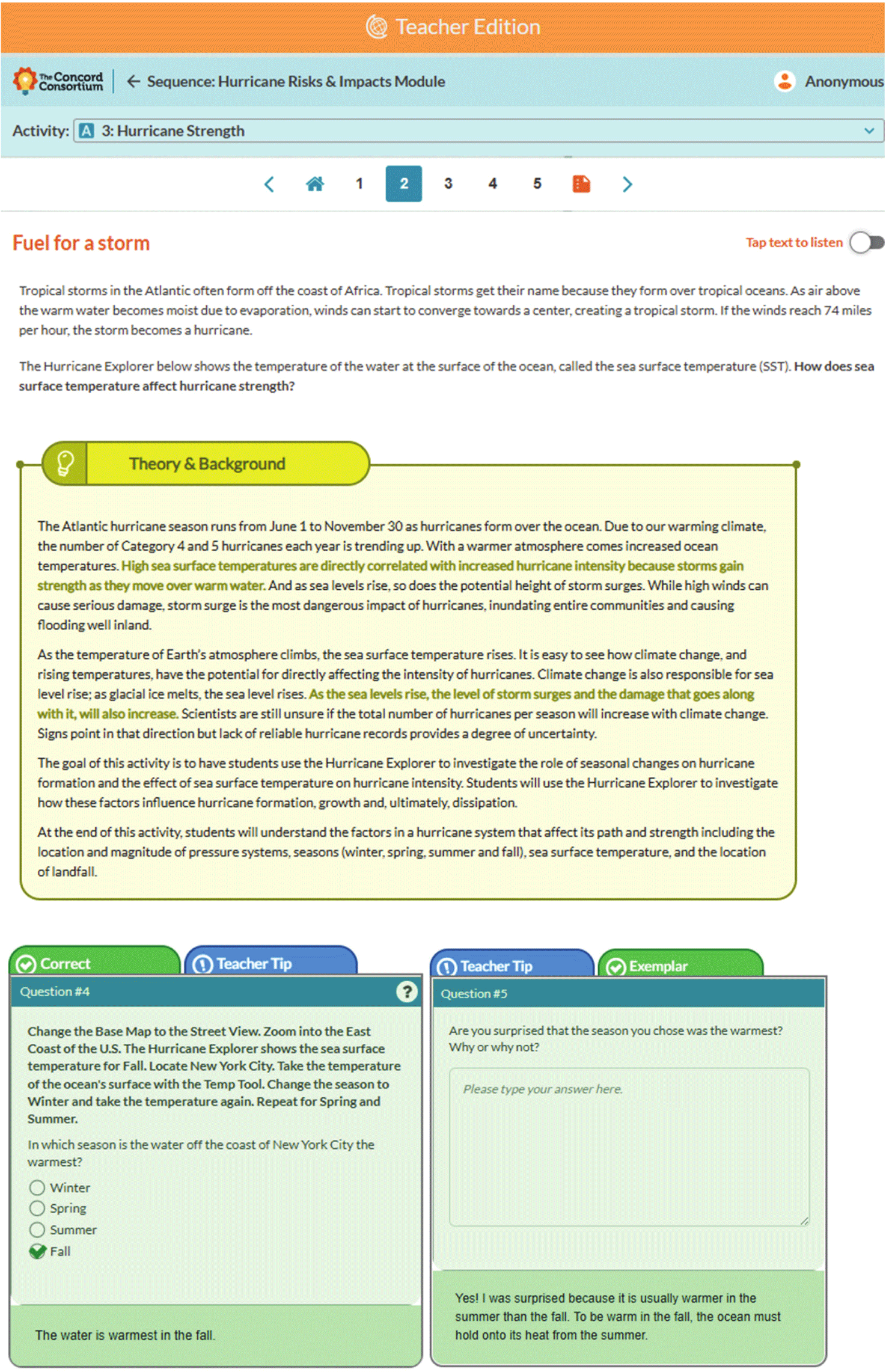
The Teacher Edition included a range of supports, such as explanations of key scientific content and concepts, rationales for correct and distractor choices in multiple-choice questions, tips for eliciting and responding to evolving student ideas, strategies for supporting struggling learners, extension opportunities, exemplar responses to open-ended questions, instructional guidance for teaching with the Hurricane Explorer, and discussion prompts to facilitate classroom conversations [25]. These pedagogical supports were integrated as a Teacher Edition overlay to the Hurricane Module. For example, Fig. 5 shows the layout of some of the Teacher Edition elements for the second page of Activity 3. The “Theory and Background” on sea surface temperature explains how sea surface temperatures vary by season and influence hurricane development. Teachers are shown the correct answer to the multiple-choice question along with reasoning tips, as well as an exemplar answer for the open-ended question. As teachers navigated the Teacher Edition of the Hurricane Module, their interactions with these pedagogical resources were automatically logged. We used this log data to verify that all participating teachers had accessed and reviewed the Teacher Edition as part of their self-guided preparation.
In post-implementation survey analysis, teachers most frequently cited the importance of strategies for teaching with the Hurricane Explorer and discussion prompts, each selected by five teachers. Four teachers reported finding value in tips for eliciting evolving student ideas, strategies for supporting struggling students, extension suggestions, and exemplar answers to open-ended questions. All teachers read the Teacher Edition prior to the module implementation. In addition, six teachers used the Teacher Edition between class periods while five used it during instruction. The Teacher Edition was reported to be helpful for both teachers with limited background knowledge and those with more advanced understanding of the Earth science content in the Hurricane Module. One teacher shared, “The extra materials help ground my thinking prior to implementation. It helps me recognize my own misunderstandings, so they do not become student misunderstandings,” highlighting how the teacher resources supported content confidence and instructional clarity. Another teacher, who described themself as knowledgeable about hurricane science, noted:
“Even as a veteran teacher, I need help with promoting thinking in the classroom and really knowing when to present an idea or ask a question. Also, having the answers is necessary to make sure we (teacher and student) truly understand the question being asked. If I do not MAKE the questions, I may not be thinking in the same frame with the same goals as the person who did make the questions. That is why it is vital to have another person read through and try to answer your questions (you make) to recognize if they are clear to students.”
This suggests that even experienced educators benefited from the depth and completeness of the provided supports.
In the post-implementation teacher survey, four teachers reported using the Hurricane Module as a replacement for their previous hurricane-related instruction, while one teacher used it as a supplement. Two teachers used the module to teach hurricanes for the first time. As part of the survey, teachers were asked how frequently they used a set of nine inquiry-promoting strategies when teaching the module and selected one of the three choices: frequently, somewhat, or rarely. Table 4 shows the teaching strategies utilized by the teachers. The most common practice, selected by six teachers, was helping students think about risks in terms of the likelihood of damages and losses. This was followed by making predictions and testing ideas using the Hurricane Explorer and facilitating whole-class discussions to synthesize students’ ideas, each reported by four teachers. The least used strategy was having students use climate data to project future risks and impacts, selected by two teachers. Across all participants, Teacher E and Teacher F reported using the greatest number of inquiry-based strategies, while Teacher C reported using the fewest. A general pattern also emerged, suggesting that high school teachers tended to use more inquiry-oriented teaching strategies than their middle school counterparts during the Hurricane Module.
The post-implementation survey asked teachers how they supported students’ use of the Hurricane Explorer. Five teachers reported that they worked with individual students to support their use and interpretation of the Hurricane Explorer and also projected the simulation for whole-class or small-group discussions. Teacher C reported, “Some students were certainly more proficient, so I ended up just going around and helping individual students who were really struggling! This was a much slower method, but then I saw some of these students showing nearby classmates. Peer to peer teaching is often a good pedagogy method!” Teacher B projected the simulation and worked with the simulation as a whole-class activity.
In addition, teachers were asked to indicate their level of agreement with six statements regarding how the Hurricane Explorer supported student learning. Responses were rated on a five-point Likert scale, from strongly disagree (1) to strongly agree (5). Table 5 presents teacher ratings across six statements: helping students visualize the path of a hurricane, understand the strength of a hurricane, grasp hurricane risks, recognize the impact of increasing sea surface temperatures, understand the influence of high- and low-pressure systems on storm tracks, and appreciate the role of uncertainty in hurricane forecasting. Most teachers selected “agree” or “strongly agree” for each area, indicating a generally positive perception of the Hurricane Explorer’s value as an instructional tool. Average ratings across the six categories were relatively consistent, ranging from 4.50 to 5.00. The exception was Teacher C, whose average rating was 3.83, suggesting some variation in perceived effectiveness, potentially related to differences in instructional use.
the participating teachers from seven schools administered a hurricane literacy test to their 199 students before and after implementing the Hurricane Module. Among the students, 42% were high school students; 36% were non-White students; 37% had prior hurricane experience; 53% were not male students; 5% spoke English as a second language; and 95% had prior experience using computers for science learning.
The hurricane literacy test was developed to assess students’ understanding of the eight hurricane literacy statements outlined in Table 1. The test included 13 multiple-choice (MC) items, 7 true/false (TF) items, and 12 explanation items. Multiple-choice and true/false items were scored as 0 (incorrect/false) or 1 (correct/true), except for one multiple-choice item that was scored from 0 to 2 for allowing two correct choices. The explanation items were evaluated using a knowledge integration scale ranging from 0 to 4: 0 (blank/off-task), 1 (vague or incorrect scientific ideas only), 2 (single scientifically valid idea), 3 (two scientifically valid ideas), and 4 (three or more scientifically valid ideas). The test demonstrated strong internal consistency, with a Cronbach’s alpha of 0.87. The maximum possible hurricane test score was 69.
Fig. 6 provides an example of a multiple-choice item paired with an open-ended explanation item. In the multiple-choice item, students are asked to determine which hurricane would cause greater precipitation-related damage, based on differences in storm path and duration. The question emphasizes the understanding that a slower-moving or lingering hurricane can produce more severe impacts due to prolonged exposure. This item pair aligns with hurricane literacy statement H3: “Hurricane hazards can impact human lives, health, properties, and infrastructure.” The corresponding learning goal is addressed in Activity 4, where students analyze changes in hurricane size, strength, and path to determine whether a storm poses natural hazards to people in its projected path.
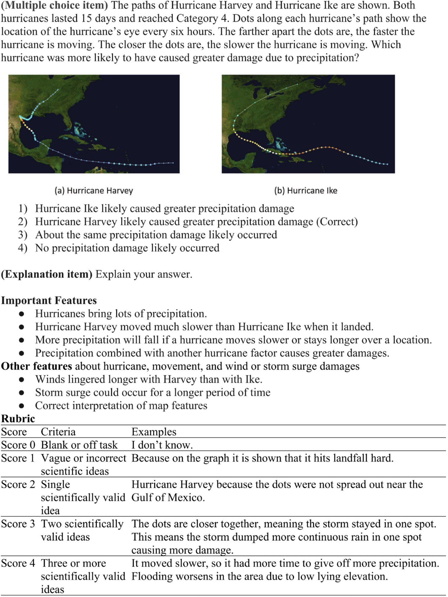
Table 6 presents the hurricane literacy pretest-posttest comparison results, demonstrating significant student improvement following the implementation of the Hurricane Module. As a whole, students (n=199) showed a statistically significant increase in scores based on paired samples t-tests, with an effect size of 0.63 in Cohen’s d. This effect size falls between medium and large, based on standard interpretation criteria, where small effects are around 0.2, medium effects around 0.5, and large effects around 0.8.
Although 199 students completed both the pretest and posttest, analyses involving demographic variables were conducted using only the subset of students who provided responses to each specific demographic question. Students with missing responses for a given variable were excluded from that particular analysis.
Table 6 further details the mean pretest and posttest values across various demographic subgroups, along with their respective effect sizes in Cohen’s d. The gender variable was categorized as male vs. non-male (combining female, non-binary, and “prefer not to answer” responses). The race variable was represented as White vs. non-White, while additional subgroup analyses examined differences based on prior hurricane experience (yes vs. no) and English as a primary or secondary language. Results indicate that all subgroups significantly improved from pretest to posttest, exhibiting effect sizes ranging from 0.52 (medium) to 0.86 (large). These findings suggest that the Hurricane Module is effective in developing student’s hurricane literacy across diverse populations, regardless of gender, race, English proficiency, school level, or prior hurricane experience.
To identify significant predictors of hurricane literacy posttest scores, we used 174 students who responded to all demographic questions, the pretest, the posttest, and the Hurricane Module. We created three covariates: students’ pretest scores, module completion, and simulation engagement within the Hurricane Module. The module completion variable was calculated as the number of module’s prompts a student responded to, divided by the total number of prompts (136 total prompts), where a value of 1 indicates full completion. The simulation engagement variable represented the number of completed simulation tasks, ranging from 0 to 8. We initially tested a full factorial general linear model by entering all demographic variables listed in Table 6 as fixed effects, with pretest score, module completion ratio, and simulation engagement variables included as covariates. This analysis revealed a significant interaction effect between race and hurricane experience. Based on these findings, we refined the general linear model to include the main effects of gender, English proficiency, race, school level, and hurricane experience, along with the interaction effect between race and hurricane experience and the three covariates. The final model presented in Table 7 explained 57% of the variance in posttest scores (R2=0.57).
By applying the partial η2 effect size interpretation—where values around 0.01 indicate a small effect, 0.06 a medium effect, and 0.14 a large effect—we identified four significant predictors. The pretest score showed a large effect, while both school level (high school vs. middle school) and the interaction between non-White race and hurricane experience exhibited small-to-medium effects. The significance of pretest scores suggests that students with greater prior hurricane literacy were more likely to score higher on the posttest (r=0.69, p<0.001). As shown in Table 6, high school students outperformed middle school students on the posttest, which is consistent with expectations, given that high school students typically possess stronger prior science knowledge and more developed inquiry skills, such as using simulations effectively, analyzing data, and constructing explanations.
We also found that simulation engagement—measured by the number of simulation tasks completed—was a significant predictor of hurricane literacy posttest scores, with a small-to-medium effect, whereas overall module completion was not. This finding highlights the importance of active engagement with simulations as a key driver of student learning. Simulation-based investigations may support students in developing a deeper understanding of hurricane science, including the factors influencing storm path and intensity and forecasting of timing and locations of impacts. Such understanding can, in turn, strengthen students’ grasp of broader hurricane literacy concepts, including climate-related impacts, and hazard and risk assessment.
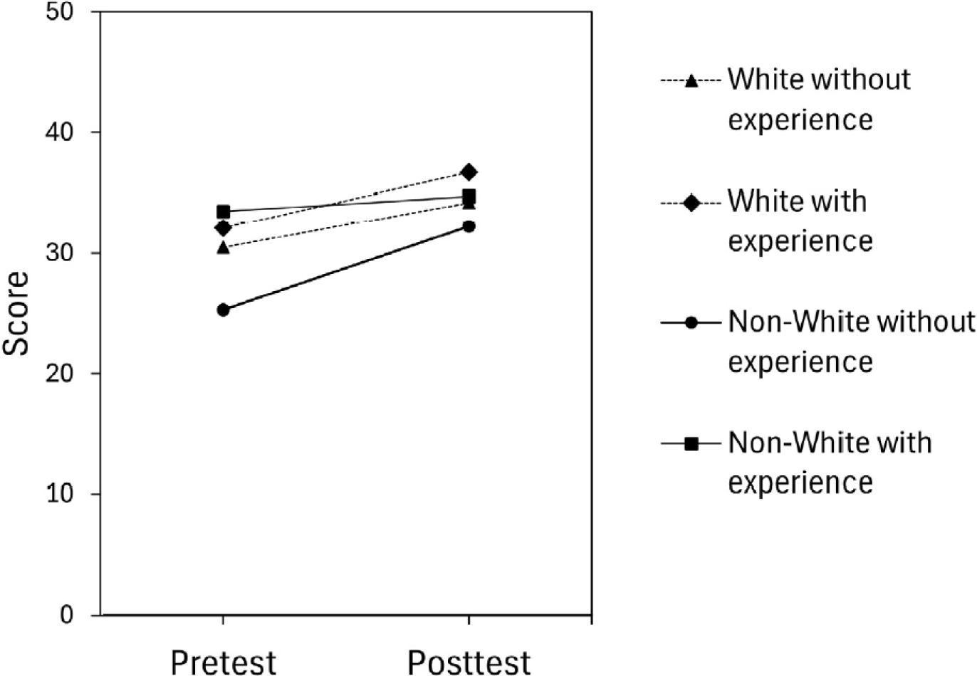
To further investigate the interaction effect, we compared pre- to posttest mean changes among non-White students with and without prior hurricane experience, and White students with and without prior hurricane experience. Fig. 7 illustrates that, in general, students with hurricane experience had higher pretest scores across both racial groups. However, non-White students without prior hurricane experience started with the lowest pretest scores, showing a notable gap compared to the other groups. While all groups demonstrated improvement, this group showed the greatest gains, suggesting that the Hurricane Module’s simulation-based activities may have been particularly effective in supporting students who lacked prior exposure. While this finding highlights the potential of simulations to offer meaningful learning experiences in the absence of direct experience, the effect may not be solely due to personal hurricane experiences. Other contributing factors may include differences in students’ prior inquiry skills, familiarity with simulation-based learning, or how they engaged with the inquiry process, such as their ability to change variables, interpret simulation outputs, and construct explanations.
Discussion
In this paper, we explored how computer simulations can be designed and used as an integral part of enhancing natural hazard literacy in the context of hurricanes. By defining hazard literacy, we established a pedagogical framework encompassing mechanisms, likelihood, impacts, and mitigation strategies associated with natural hazards. We examined the nature of computer simulations, particularly their affordances and limitations in engaging students with simulation-based investigations to develop hazard literacy. The affordances of simulations are to be realized through students’ intentional and reflective interactions, as they change variables, observe outcomes, compare results across trials, and test and refine their ideas about the phenomena depicted in the simulation. While simulations are designed to support their inquiry-based discovery, students may not always construct the designers’ intended meanings without explicitly structured activities. Thus, the careful design of student investigations is essential to optimize simulation-based learning opportunities for hazard literacy. To illustrate this, we provided examples of investigations using the Hurricane Explorer, demonstrating how simulation and investigation activity design work together to reinforce hurricane literacy concepts.
We examined students’ pretest to posttest improvement in hurricane literacy, highlighting the importance of well-designed simulation-based investigations in advancing students’ hurricane literacy. Just as the Hurricane Explorer allows students to experiment with environmental factors affecting hurricane formation, similar simulation-based scientific investigations could help students investigate seismic activity, wildfire spread patterns, or flood dynamics. Using the same approach as described in this paper, we also developed simulation tools and modules with simulation-based scientific investigations and classroom-tested each with significant improvements in hazard literacy related to wildfires [26], floods [12], earthquakes [27], and volcanic eruptions [28].
Learning outcomes in this study indicate that the Hurricane Module was especially effective for students who had not previously experienced hurricanes, with non-White students without hurricane experience showing the greatest learning gains. This suggests that simulation-based learning can provide sufficient virtual experience needed for students who lack direct prior experience. By allowing students to visualize hazards and interact with computational models, simulations are important inquiry tools for exploring large systems and may help bridge gaps in hazard literacy and foster more inclusive hazard education opportunities in diverse classrooms.
To maximize the educational value of natural hazard simulations, design considerations must balance scientific validity of models with usability. While scientific models account for numerous complex variables, educational simulations must simplify certain elements without compromising conceptual integrity. The Hurricane Explorer, for example, allows students to change environmental conditions but does not incorporate dynamic changes such as evolving atmospheric conditions. Recognizing these design constraints is essential in ensuring that simulations provide a manageable yet realistic representation of natural hazards. Structured investigations, therefore, should be designed to scaffold inquiry so that students not only interact with the simulation but also reflect on their findings, evaluate uncertainties, and connect their learning to real-world hazard situations and preparedness.
While simulations can provide powerful learning opportunities, we are fully aware that their effectiveness depends on how they are integrated into teacher instruction and classroom culture. Teachers need support and resources to facilitate student engagement with simulations in meaningful ways. In this study, participating teachers were given access to teaching tips, insights on simulation use, exemplar student responses, discussion strategies, and assessment materials, ensuring they had guidance on how to implement the Hurricane Module effectively. Future efforts in simulation-based hazard education should consider professional development programs or instructional strategies that can help teachers build confidence in using simulations, guiding students through uncertainty, and connecting simulation-based learning to real-world hazard preparedness efforts. Future research can examine different ways teachers use the Hurricane Explorer and use video analysis and classroom observations to explore teacher and student discourse around simulation use.
This study examined the overall learning outcomes of the full Hurricane Module intervention, rather than isolating the effects of each individual simulation task. We acknowledge that the affordances and limitations of simulations in supporting student learning of specific concepts or inquiry skills are best understood through detailed analyses of students’ actual simulation use and reasoning processes. Such insights require close examination of student engagement with each simulation task at the individual or small-group level. Because each simulation-based task is designed to elicit different types of understanding, our future research will focus on analyzing student discourse and behavior using computer log data and video recordings to investigate how learners interact with simulations and construct meaning from those experiences.