
Introduction
Natural disasters are major geographical phenomena shaped by human-environment interactions, and understanding and preparing for them is a key objective of geography education [1,2]. As climate change increases the frequency and intensity of disasters, it is crucial to equip students with the knowledge and skills to analyze their causes, assess their impacts, and develop effective response strategies [3,4]. However, disaster education in schools in South Korea primarily focuses on categorizing disaster types and teaching general preparedness measures, offering limited opportunities for students to investigate region-specific risks or engage in problem-solving activities [5].
The rapid advancement of geospatial technologies has opened new possibilities for enhancing disaster education through inquiry-based learning. Geospatial Web Services (GWS) address the limitations of traditional disaster education by providing interactive spatial data [6]. For example, the Ministry of the Interior and Safety’s ‘Safety Map’ platform offers data on landslide risks, flood hazards, and earthquake occurrences, while the Korea Meteorological Administration’s “Open Data Portal” provides information on extreme weather events. These services enable students to visualize and analyze real-time disaster risk data provided by government agencies and public institutions [7,8].
Despite their potential, GWS have not yet been systematically integrated into disaster education [9]. Furthermore, geography teachers often lack opportunities to engage with geospatial tools and inquiry-based methodologies in professional development settings, limiting their ability to implement these approaches in classrooms [10,11]. To bridge this gap, this study proposes a GWS-based inquiry model, and then applies it to develop a lesson plan for disaster education. Additionally, the lesson plan was pilot tested in a small-scale teacher workshop to explore its feasibility in instructional practice.
Based on this framework, the study aims to answer the following research questions:
Literature Review
Geography education has been recognized as a crucial tool for disaster education, as it enables students to assess risks using geospatial skills and enhances their resilience [12,13]. However, current curricula often fail to integrate applied learning activities that allow students to practice risk assessment and mitigation strategies. Prevailing disaster education approaches primarily focus on categorizing disaster types and teaching general preparedness guidelines, rather than equipping students with practical skills for real-world disaster scenarios [5]. While this approach provides foundational knowledge, it does not sufficiently develop students’ spatial awareness, critical thinking, or decision-making abilities, which are essential for effective disaster preparedness [14].
A significant limitation of disaster education is its reliance on standardized content, which often lacks regional specificity. Most curricula emphasize national-level policies and generalized preparedness training, overlooking local variations in disaster risk. However, because natural disasters tend to recur in specific regions and are influenced by seasonal and climatic changes, disaster education should equip students with the ability to analyze risks across multiple spatial scales—from global to local—allowing them to connect localized hazards to broader environmental and climatic trends [2]. Research further suggests that a localized, inquiry-driven approach not only enhances students’ geographical understanding but also fosters their awareness and sense of responsibility as community members, empowering them to actively contribute to disaster risk reduction [3,5].
Effective disaster education moves beyond passive knowledge acquisition by incorporating hands-on, inquiry-based learning approaches [15]. Studies have shown that methods such as problem-based learning, field investigations, and community engagement projects significantly enhance students’ ability to assess risks and develop mitigation strategies [16]. Furthermore, research indicates that student engagement and knowledge retention improve when disaster education actively involves learners, rather than relying solely on information delivery [17].
GWS are web-based platforms that allow users to search, visualize, and analyze spatial data interactively [7,8]. These platforms integrate various geospatial sources, such as street view, aerial imagery, and satellite imagery, with thematic geographic data to provide comprehensive insights. As public institutions and research organizations increasingly share their geospatial data in interactive formats, the range and scope of GWS applications continue to expand [6].
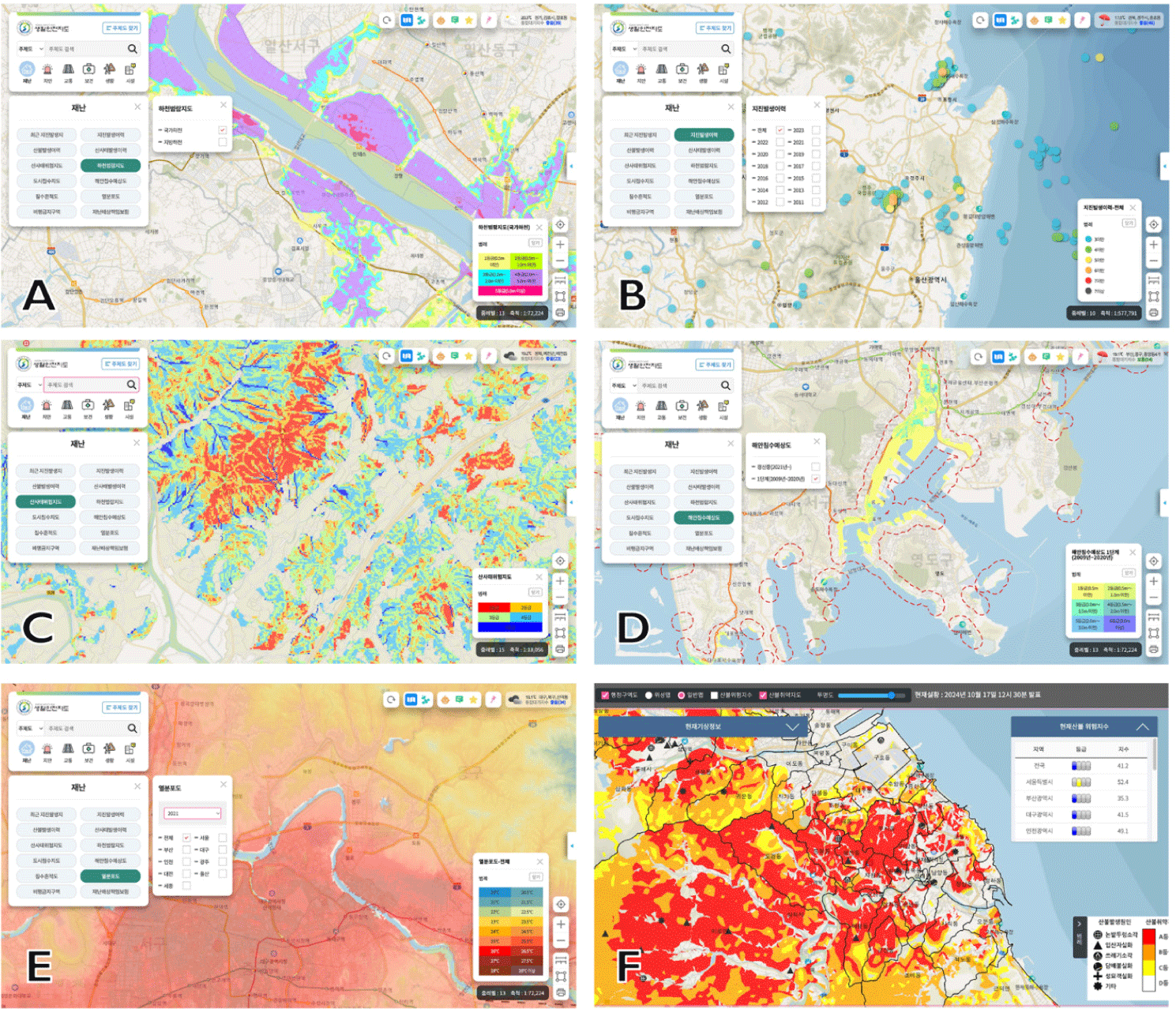
Several major GWS platforms in South Korea exemplify the increasing role of geospatial technologies in disaster monitoring and education. Institutions such as the Statistical Geographic Information Service, the National Spatial Information Map, and the River Management Geographic Information Service operate and provide disaster related GWS, offering foundational geospatial data. Additionally, specialized platforms like the National Safety Map integrate geospatial tools for assessing and mitigating disaster risks. Among the various disaster-related datasets available through GWS, those related to river flooding, coastal inundation, landslides, earthquake occurrences, and wildfire risks are particularly relevant to disaster education (Fig. 1). For instance, river flood maps provide graded assessments of historical and potential inundation levels, enabling users to examine specific locations and analyze factors such as flood causes (e.g., heavy rainfall-induced overflow), expected water depth, and flood duration.
Given these applications, GWS provides several key educational advantages. First, its accessibility and low cost make it widely available, as it requires only an internet connection rather than specialized software or hardware [7,18]. Second, its interactive learning environment enhances student engagement by promoting hands-on exploration, making geography more dynamic [19,20]. Third, real-world, localized data allows students to examine issues within their own communities [9,21]. Fourth, GWS facilitates spatial analysis across multiple regions, enabling students to compare and analyze geographic differences across various locations [7,22]. Finally, GWS relies on reliable and continuously updated data, as it is supported by national and governmental datasets, ensuring accuracy in educational applications [23].
Inquiry-based learning, rooted in constructivist learning theories, is a general approach that emphasizes active student engagement with real-world data to explore questions, analyze patterns, and draw conclusions [24]. Geospatial inquiry extends this approach by integrating geospatial technologies, allowing students to investigate spatial relationships and analyze geographic data as part of their inquiry process [25]. As a subset of geospatial inquiry, GWS-based inquiry specifically focuses on the use of GWS to facilitate spatial analysis and decision-making in an interactive and accessible manner. By leveraging real-time, publicly available geospatial datasets, this approach reduces the technical barriers often associated with traditional GIS software while fostering deeper geographical thinking [7].
Inquiry-based learning exists along a spectrum, from structured inquiry, where students analyze predefined datasets, to open inquiry, where they generate their own questions and collect data [24]. GWS support structured inquiry by providing readily available, well-organized spatial data that serves as both a guide and a framework for exploration, helping students focus their inquiry within established parameters. Because these datasets are pre-processed and delivered through online platforms, students engage in evaluation, selection, and interpretation rather than primary data collection. This shifts the emphasis from raw data acquisition to critical analysis and decision-making, reinforcing structured inquiry’s focus on guided exploration.
To further conceptualize how structured inquiry can be applied within GWS-based learning, existing geospatial inquiry models provide useful frameworks for structuring the learning process. Nolan et al. [25] proposed a six-step Geospatial Inquiry process, which includes examining data, asking questions, acquiring additional data, analyzing and interpreting information, arguing from evidence, and revising arguments. Similarly, Fargher [7] outlined a five-step Geo-Inquiry model, where students engage in a sequence of asking, collecting, visualizing, creating, and acting on geospatial information. These models illustrate how GWS enhances inquiry by incorporating spatial analysis, data visualization, and real-world decision-making (Table 1).
Developing a Geospatial Web Services (GWS)-Based Inquiry Model
This study aims to develop a structured inquiry model that integrates GWS, and to apply this model to design a lesson plan for disaster education. The primary focus is to first establish key design principles for GWS-based inquiry, and then develop a disaster education lesson plan grounded in this model. Rather than adopting an empirical data collection approach, this study follows a design-based approach, emphasizing the structured development of instructional materials that integrate GWS. The study consists of three key phases:
-
Identifying Design Principles – Reviewing the literature on geospatial inquiry and geography education to establish pedagogical guidelines for integrating GWS.
-
Developing the Instructional Model – Creating a structured inquiry-based model tailored to GWS-based inquiry.
-
Applying the Model to Disaster Education – Designing a disaster lesson plan by applying the developed instructional model.
By structuring the inquiry process into distinct phases, this study provides a practical framework for integrating GWS into disaster education. The final instructional model is evaluated conceptually in terms of its alignment with established inquiry-based frameworks and its feasibility for classroom implementation.
Inquiry-based learning provides a structured approach to engaging students in geographical problem-solving using real-world data. In this context, GWS enhances this inquiry process by offering interactive spatial analysis tools, enabling students to dynamically investigate geographical phenomena dynamically and in real time. Table 2 outlines the key design considerations that informed the development of the Structured GWS-Based Inquiry Model. These considerations were derived from an extensive review of literature in geospatial inquiry and geography education, and are organized into three essential components:
| 1. Inquiry-based instructional approach | |
| 1.1. Real-world problems | Inquiry topics should be relevant to students’ daily lives and reflect authentic geographical issues [11,26]. |
| 1.2. Question-driven inquiry | Inquiry questions should stimulate students’ curiosity and promote geographical thinking [24]. |
| 1.3. Evidence-based inquiry | Students should collect, analyze, and interpret data to support claims and conclusions [25,27]. |
| 1.4. Data analysis and conclusion drawing | Guide students in analyzing spatial patterns and relationships to draw meaningful conclusions. |
| 1.5. Reflection | Provide opportunities for students to critically reflect on their inquiry process and problem-solving strategies [24]. |
| 1.6. Active student engagement and collaboration | Students should actively participate in problem-solving, evaluating data, and constructing conclusions. Encourage collaboration and peer interaction [25]. |
| 1.7. Scaffolding | Provide structured guidance to support students’ inquiry process while gradually reducing assistance [11]. |
| 2. Use of GWS in learning | |
| 2.1. Educational suitability | Select appropriate GWS that align with learning objectives and evaluate their effectiveness compared to other data sources. |
| 2.2. Accessibility and user-friendliness | Ensure that the selected GWS platforms are easy to access and navigate [7,18]. |
| 2.3. Use of real-time and dynamic data | Enable students to explore and analyze continuously updated datasets to enhance inquiry-based learning [7,8]. |
| 2.4. Interactive data exploration | Utilize GWS functionalities such as zooming, panning, and filtering to allow students to manipulate and explore data dynamically [28]. |
| 2.5. Spatial analysis tools | Support students in using spatial analysis functions such as measuring distances, overlay analysis, buffering, and hotspot detection [27]. |
| 2.6. Data visualization and interpretation | Promote the use of maps, graphs, and spatial analytics tools to enhance data comprehension and storytelling [26]. |
| 3. Geographical knowledge and skills | |
| 3.1. Curriculum alignment | Ensure that learning objectives align with geography curriculum standards [29]. |
| 3.2. Knowledge and understanding | Develop students’ comprehension of geographical concepts, principles, and real-world phenomena [10]. |
| 3.3. Inquiry process and skills | Provide students with opportunities to engage in inquiry and apply findings to problem-solving and decision-making. Develop spatial analysis skills, including recognizing spatial distributions, patterns, and relationships [21]. |
| 3.4. Values and attitudes | Foster awareness, ethical considerations, and active participation in addressing geographical challenges [29]. |
| 3.5. Spatial thinking and multi-scale reasoning | Encourage students to examine local, national, and global issues, helping them connect local-scale investigations with broader geographical contexts [30]. |
-
An inquiry-based instructional approach
-
The effective use of Geospatial Web Services (GWS)
-
The development of geographical knowledge and skills.
The first component emphasizes authentic, question-driven, evidence-based inquiry processes. It highlights the importance of engaging students with real-world problems, facilitating data-driven reasoning, and supporting reflection and collaboration through scaffolding. The second component focuses on selecting appropriate GWS platforms that align with learning objectives, are accessible and user-friendly, and allow students to explore and analyze spatial data interactively in real time. The third component emphasizes the development of students’ geographical reasoning by aligning with curriculum standards, fostering spatial thinking, and encouraging multi-scale analysis and ethical engagement with geographical issues.
To bridge the theoretical foundation established in the literature review with its practical application, this study proposes a structured GWS-based inquiry model that translates inquiry principles into a sequential, action-oriented process for students. While previous models, such as Nolan et al.’s [25] six-step Geospatial Inquiry process and Fargher’s [7] five-step Geo-Inquiry model, have emphasized the integration of spatial reasoning and decision-making in geography education, these models do not explicitly incorporate the dynamic and interactive nature of GWS. The model presented in Table 3 structures GWS-based inquiry into five interconnected phases, each guided by key questions that promote critical thinking, spatial data evaluation, and real-world problem-solving. The five phases include: (1) defining the inquiry question and its importance, (2) identifying and evaluating geospatial data, (3) analyzing spatial data and detecting patterns, (4) drawing conclusions based on spatial evidence, and (5) applying findings to real-world decision-making.
Unlike conventional linear inquiry models, this GWS-specific approach is iterative and multi-scale, allowing students to refine their investigation dynamically by adjusting spatial scale, integrating real-time data, and applying geospatial analysis techniques. Table 3 outlines these five phases, which include defining the inquiry question, evaluating data, conducting spatial analysis, applying evidence-based reasoning, and making real-world decisions. By actively engaging in these stages, students construct knowledge rather than passively consuming information, making GWS-based inquiry an effective tool for geography education.
Applying the Model to Natural Disaster Education
This section demonstrates how the proposed GWS-based inquiry model was applied to design and structure a lesson plan for disaster education, illustrating how each phase of the model was implemented to support students’ inquiry, spatial analysis, and decision-making skills.
To effectively integrate GWS into disaster education, this study identified and applied a selection of geospatial datasets relevant to disaster risk assessment. These datasets, sourced from government and research institutions, provided real-time or historical data on hazards such as floods, landslides, typhoons, wildfires, and earthquakes (Table 4). The selection of GWS datasets was guided by three key criteria:
-
Relevance to Inquiry-Based Disaster Education – The datasets needed to align with the structured inquiry model, allowing students to explore disaster risks through spatial reasoning and evidence-based decision-making.
-
Multi-Scale Geographical Insights – Selected datasets provided disaster risk assessments at various geographical scales, from national to regional and local levels, supporting comparative spatial analysis.
-
Facilitation of Student-Led Spatial Analysis – The datasets enabled students to engage with real-world geospatial data, apply analytical skills, and assess potential disaster mitigation strategies.
To ensure clarity and accessibility, students are not required to independently select disaster types or datasets. Instead, the lesson plan provides a curated set of nine geospatial datasets, each with corresponding worksheets that guide students through specific analytical criteria (as detailed in Table 4). For example, in the case of river floods, students assess risks from overflow or embankment collapse and classify risk levels from 1st to 5th grade. For landslides, they examine slope, soil conditions, and precipitation history. These guided materials enable meaningful engagement with real-world spatial data, even for students without prior experience in geospatial analysis.
The following section outlines a hypothetical instructional scenario designed to demonstrate how the Structured GWS-based inquiry model can be applied to disaster education (Table 5). This scenario illustrates the pedagogical intent and practical application of each phase, providing a replicable framework for geography educators.
The lesson begins with the central inquiry question: “What natural disasters occur most frequently in our region?” The teacher introduces this question to establish relevance and encourage students to connect geographical inquiry to their own experiences. Students are prompted to reflect on past disasters in their area, recalling personal encounters, community knowledge, or media reports. As they consider the impacts of these disasters, they begin to question whether their perceptions align with actual risk patterns. Through this reflection, students are guided to understand why analyzing natural disasters is crucial for improving preparedness and mitigation strategies.
Before introducing specific datasets, the teacher encourages students to predict what kinds of data would be necessary to assess regional disaster risks and where such data might be obtained. This activity invites students to consider the types of spatial information that would provide insights into disaster frequency, severity, and spatial distribution. The teacher then introduces GWS platforms that provide publicly available, real-time geospatial datasets. Students are guided through pre-selected GWS platforms, including the Living Safety Map, Wildfire Risk System, and Meteorological Data Portals. The teacher demonstrates how these platforms operate and explains key considerations such as data reliability, relevance, and limitations. Students then explore the platforms and critically evaluate which datasets would best support their inquiry.
With a clear understanding of the available datasets, students conduct a structured disaster risk assessment for their region. They analyze the nine pre-selected datasets and apply spatial analysis techniques to evaluate risk patterns. Using interactive GWS tools, students overlay datasets, filter data to highlight high-risk zones, and compare patterns at local, regional, and national scales. During this process, students explore correlations such as the overlap between flood-prone zones and high-density areas, or the proximity of earthquake risk zones to active fault lines. Their findings are compiled in a Disaster Risk Assessment Report, which documents insights from each dataset and supports evidence-based reasoning.
Following their analysis, students synthesize findings to determine which natural disaster poses the greatest threat to their region. They evaluate multiple datasets, identify key spatial trends, and formulate conclusions based on geospatial evidence. To deepen their analysis, the teacher leads a discussion on data reliability and the interpretive limits of different sources. Students reflect on how conclusions vary depending on the datasets used and why triangulating data is crucial in spatial inquiry. Through this process, they learn to evaluate and communicate geographic conclusions with analytical rigor.
In the final phase, students explore how their findings could inform actual disaster preparedness and response efforts. They review national and local disaster management policies and identify which agencies are responsible for their region’s disaster response. Students evaluate whether these policies sufficiently address the hazards identified in their analysis and are encouraged to suggest improvements. They reflect on the following questions:
-
How effective are existing disaster management strategies?
-
What additional measures could improve community resilience?
-
How could their findings inform local policymakers?
Students then propose data-based recommendations through group presentations. This stage bridges analysis with civic engagement, allowing students to understand the societal relevance of their inquiry and reinforcing spatial citizenship through real-world application.
Discussion: Insights from Preliminary Implementation
This study examined the potential of integrating GWS into disaster education and outlined key considerations and steps for developing instructional materials. Traditional disaster education primarily focuses on theoretical concepts and generalized preparedness measures, often limiting students’ opportunities to engage in region-specific risk analysis [5]. The GWS-based inquiry model, as applied in this study, enables students to move beyond passive knowledge acquisition and actively explore disaster risks through inquiry, geospatial analysis, and data-driven decision-making.
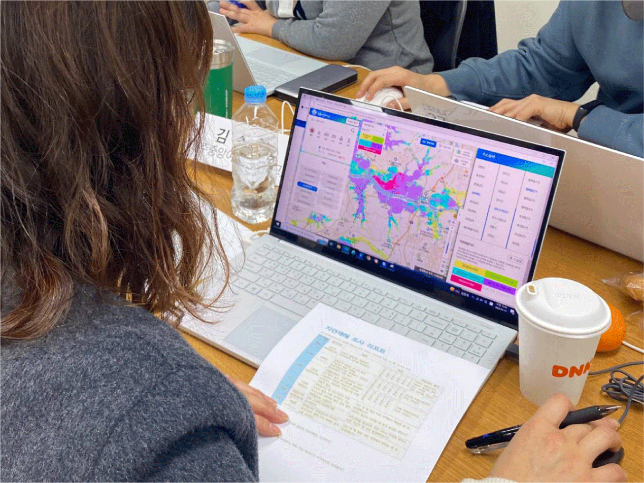
To gain preliminary insights into the feasibility of implementing the GWS-based inquiry model in educational settings, a small-scale teacher workshop was conducted (Fig. 2). While not a primary research component, this trial application provided valuable feedback from 13 geography teachers regarding the model’s instructional potential and practical challenges.
Teachers who participated in the professional development workshop generally recognized that the GWS-based inquiry model offers distinctive educational benefits compared to conventional approaches to disaster education. The most frequently cited advantage was its ability to provide opportunities for students to explore natural disasters within their local context. While traditional disaster education often focuses on conceptual understanding and generalized preparedness measures, GWS-based inquiry allows students to analyze real-time data and investigate disaster risks specific to their region. Teachers noted that this structured GWS-based inquiry approach enables more meaningful learning experiences by fostering direct engagement with geospatial data. Another key strength highlighted by participants was the ability of spatial data to facilitate a more intuitive and visually driven analysis of natural disasters. Several teachers pointed out that conventional disaster education tends to emphasize theoretical explanations, leaving students with limited experience in working with actual data. In contrast, GWS-based inquiry enables students to interpret disaster-related spatial patterns through interactive maps and real-world datasets. Teachers emphasized that using map-based representations allows students to better understand the distribution and impact of natural disasters, thereby enhancing their spatial reasoning and analytical skills. Additionally, some teachers noted that the GWS-based inquiry model has potential applications beyond disaster education. They suggested that the approach could be extended to topics such as climate change, urban development, and regional economic analysis. For instance, discussions emerged on mapping regional population decline, analyzing tourism hotspots through spatial data, and visualizing the impacts of climate change on different landscapes. These insights suggest that GWS-based inquiry could serve as a versatile framework for integrating geospatial analysis into a wide range of geography topics.
Despite the promising benefits of GWS-based inquiry, workshop participants also identified several challenges that must be addressed to facilitate its successful implementation in classrooms. First, the complexity of geospatial data and its interpretation was cited as a major obstacle. Teachers expressed concerns that students might struggle with analyzing multi-layered spatial datasets, especially if they have limited prior experience with GWS tools. Some noted that the interface and functionalities of certain platforms may not be intuitive, which could hinder students’ ability to engage meaningfully in the inquiry process. Without sufficient scaffolding, students may find it difficult to extract meaningful insights from the data. Second, disparities in technological access and digital literacy among students and schools were highlighted as significant barriers. Some teachers reported that internet access and device availability vary considerably between schools, which could impact the feasibility of using GWS in the classroom. Additionally, students’ familiarity with digital mapping technologies differs widely, making it necessary to provide structured support to ensure equitable participation. Third, the need for more professional development and instructional support was emphasized as a key factor for the broader adoption of GWS-based inquiry. While teachers recognized the educational value of GWS-based inquiry, many felt that they required additional training to confidently guide students through data analysis and map interpretation. Several participants noted that they lacked prior experience in conducting spatial analysis with students and were uncertain about which aspects of digital mapping should be emphasized in instruction.
This study presents a GWS-based inquiry model specifically designed to enhance disaster education by integrating real-time geospatial data into inquiry-based learning. Unlike conventional disaster education, which often relies on static content and generalized preparedness strategies, this approach enables students to engage in localized, interactive hazard assessments using publicly available geospatial datasets. By fostering inquiry skills, geospatial literacy, and evidence-based decision-making, the model provides students with a structured framework for assessing disaster risks, analyzing vulnerabilities, and formulating mitigation strategies based on real-world data.
The integration of GWS into disaster education has significant implications for improving risk literacy and preparedness. Disaster risks vary widely by location, yet traditional disaster education often presents hazards in a generalized manner, failing to account for local variations in exposure and vulnerability. The GWS-based inquiry Model offers a solution by enabling students to analyze disaster risks specific to their communities, fostering a place-based understanding of hazards, vulnerabilities, and resilience strategies. By incorporating real-time spatial data into disaster education, students can actively engage in risk assessment, scenario modeling, and decision-making processes that reflect the complexities of actual disaster management.
Beyond disaster education, GWS-based inquiry has broader applications across geography education. As suggested by participating teachers, this approach could be extended to other geography-related challenges, such as climate adaptation, land-use planning, and environmental sustainability. Moreover, further studies should investigate the relationship between GWS-based inquiry and key geographical competencies, including spatial thinking, spatial literacy, and geospatial problem-solving, to provide empirical evidence for its broader educational benefits.
By differentiating GWS-based inquiry from geospatial inquiry, this study contributes to the advancement of disaster education methodologies by outlining the key principles, phases, and considerations necessary for its implementation. Researchers and educators can adapt and apply these principles to diverse disaster-related topics, customizing inquiry lessons to enhance disaster preparedness, risk communication, and community engagement. As geospatial technologies continue to expand, the significance of a structured GWS-based disaster inquiry framework will become increasingly important, offering a scalable and adaptable methodology for integrating GWS into disaster education.